Lehota nad Rimavicou
Lehota nad Rimavicou
Rimaszabadi | |
|---|---|
 | |
 Flag | |
 Lehota nad Rimavicou Location of Lehota nad Rimavicou in the Banská Bystrica Region  Lehota nad Rimavicou Location of Lehota nad Rimavicou in Slovakia | |
| Coordinates: 48°30′N 19°54′E / 48.50°N 19.90°E | |
| Country | |
| Region | |
| District | Rimavská Sobota District |
| First mentioned | 1274 |
| Area | |
• Total | 30.07 km2 (11.61 sq mi) |
| Elevation | 270 m (890 ft) |
| Population (2021)[3] | |
• Total | 257 |
| Time zone | UTC+1 (CET) |
| • Summer (DST) | UTC+2 (CEST) |
| Postal code | 980 53[2] |
| Area code | +421 47[2] |
| Car plate | RS |
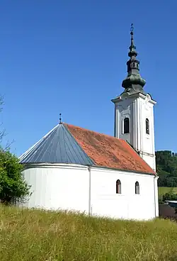
Lehota nad Rimavicou (Hungarian: Rimaszabadi) is a village and municipality in the Rimavská Sobota District of the Banská Bystrica Region of southern Slovakia.[4] Main activity of the locals had been forestry, agrobusiness and trade. Most important sightseeing is baroque-classical Lutheran church from 1796. In 2001 had been constructed Roman Catholic church.
References
- ^ "Hustota obyvateľstva - obce [om7014rr_ukaz: Rozloha (Štvorcový meter)]". www.statistics.sk (in Slovak). Statistical Office of the Slovak Republic. 2022-03-31. Retrieved 2022-03-31.
- ^ a b c "Základná charakteristika". www.statistics.sk (in Slovak). Statistical Office of the Slovak Republic. 2015-04-17. Retrieved 2022-03-31.
- ^ "Počet obyvateľov podľa pohlavia - obce (ročne)". www.statistics.sk (in Slovak). Statistical Office of the Slovak Republic. 2022-03-31. Retrieved 2022-03-31.
- ^ "Statistical Office of the slovak Republic" (PDF). Výsledky SODB 2011. Štatistický úrad SR. Archived from the original (PDF) on 2013-10-12. Retrieved 2012-08-09.
External links
 Media related to Lehota nad Rimavicou at Wikimedia Commons
- Photo gallery of Lehota nad Rimavicou
- http://www.e-obce.sk/obec/lehotanadrimavicou/4-kulturne_dedicstvo.html