Lemsterland
Lemsterland
Lemsterlân | |
|---|---|
Former municipality | |
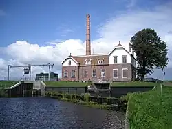 Pumping station in Echten | |
 Flag  Coat of arms | |
.svg.png) Location in Friesland | |
| Coordinates: 52°51′N 5°43′E / 52.850°N 5.717°E | |
| Country | Netherlands |
| Province | Friesland |
| Dissolved | 1 January 2014[1] |
| Area | |
• Total | 124.34 km2 (48.01 sq mi) |
| • Land | 75.93 km2 (29.32 sq mi) |
| • Water | 48.41 km2 (18.69 sq mi) |
| Elevation | 0 m (0 ft) |
| Population (November 2013)[4] | |
• Total | 13,544 |
| • Density | 178/km2 (460/sq mi) |
| Time zone | UTC+1 (CET) |
| • Summer (DST) | UTC+2 (CEST) |
| Postcode | 8508, 8530–8539 |
| Area code | 0514 |
Lemsterland (Dutch: [ˈlɛmstərˌlɑnt] ⓘ; West Frisian: Lemsterlân) is a former municipality in the northern Netherlands. In 2014 it merged with the municipalities of Skarsterlân and Gaasterlân-Sleat to form the new municipality De Fryske Marren.
Population centres
References
- ^ "Gemeentelijke indeling op 1 januari 2014" [Municipal divisions on 1 January 2014]. cbs.nl (in Dutch). CBS. Retrieved 10 January 2014.
- ^ "Kerncijfers wijken en buurten" [Key figures for neighbourhoods]. CBS Statline (in Dutch). CBS. 2 July 2013. Retrieved 11 July 2013.
- ^ "Postcodetool for 8531ED". Actueel Hoogtebestand Nederland (in Dutch). Het Waterschapshuis. Archived from the original on 21 September 2013. Retrieved 21 September 2013.
- ^ "Bevolkingsontwikkeling; regio per maand" [Population growth; regions per month]. CBS Statline (in Dutch). CBS. 23 December 2013. Retrieved 20 January 2014.
External links
 Media related to Lemsterland at Wikimedia Commons
Neighbouring municipalities at time of dissolution | ||||||||||||||||
|---|---|---|---|---|---|---|---|---|---|---|---|---|---|---|---|---|
| ||||||||||||||||