Loch Doine
| Loch Doine | |
|---|---|
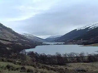 Loch Doine. Looking east across Loch Doine with Loch Voil in the background. | |
 Loch Doine | |
| Location | Perthshire, Scotland |
| Coordinates | 56°20′24″N 4°28′41″W / 56.340°N 4.478°W |
| Type | freshwater loch |
| Primary inflows | River Larig |
| River sources | River Balvaig |
| Max. length | 1.6 km (0.99 mi)[1] |
| Max. width | 0.4 km (0.25 mi)[1] |
| Surface area | 50 ha (120 acres)[2] |
| Average depth | 10.1 m (33 ft)[2] |
| Max. depth | 19.8 m (65 ft)[2] |
| Shore length1 | 4.1 km (2.5 mi)[2] |
| Surface elevation | 128 m (420 ft)[2] |
| Islands | 1 |
| 1 Shore length is not a well-defined measure. | |
Loch Doine is a small freshwater loch that lies to the west of Balquhidder in the Trossachs and Teith ward within Stirling council area of Scotland. It is a short, narrow loch. It is separated from Loch Voil to the east by a small channel. The Loch can be reached by a small single track road from Balquhidder leading to Inverlochlarig.[1][2]
References
- ^ a b c John, Murray; Lawrence, Pullar (1910). Bathymetrical Survey of the Fresh-Water Lochs of Scotland, 1897-1909 Lochs of the Forth Basin Volume II - Loch Doine. National Library of Scotland: National Challenger Officer. p. 10. Retrieved 8 May 2018.
 This article incorporates text from this source, which is in the public domain.
- ^ a b c d e f "Loch Doine". Centre for Ecology and Hydrology. Scotland and Northern Ireland Forum for Environmental Research (SNIFFER). Retrieved 7 June 2024.
Wikimedia Commons has media related to Loch Doine.