Nizhnekamsk Hydroelectric Station
| Nizhnekamsk Dam | |
|---|---|
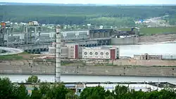 The hydroelectric power plant | |
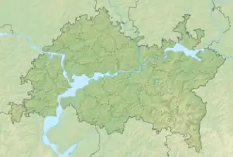 Location of Nizhnekamsk Dam in Tatarstan  Nizhnekamsk Hydroelectric Station (Russia) | |
| Official name | Nizhnekamsk Hydroelectric Plant |
| Country | Russia |
| Location | Naberezhnye Chelny, Tatarstan |
| Coordinates | 55°41′58″N 52°16′42″E / 55.69944°N 52.27833°E |
| Status | In use |
| Construction began | 1963 |
| Dam and spillways | |
| Impounds | Kama River |
| Height | 30 m (98 ft) |
| Length | 3,900 m (12,795 ft) |
| Reservoir | |
| Creates | Nizhnekamsk Reservoir |
| Total capacity | 2,800,000,000 m3 (2,269,997 acre⋅ft) |
| Surface area | 1,084 km2 (419 sq mi) |
| Power Station | |
| Operator(s) | Tatenergo |
| Commission date | 1979-1987 |
| Hydraulic head | 12.4 m (41 ft) |
| Turbines | 16 x 78 MW Kaplan turbines |
| Installed capacity | 1,248 MW |
| Annual generation | 2.54 billion kWh |
The Nizhnekamsk Hydroelectric Station (Russian: Нижнекамская ГЭС), also known as Lower Kama, is a dam and hydroelectric power station on the lower Kama River near Naberezhnye Chelny in Russia. The purpose of the dam is power production, navigation and water supply. It powers a 1,248-megawatt (MW) station with 16 x 78 MW Kaplan turbine-generators.[1] Work on the dam began in 1963 and was not completed until 1990. Work on the reservoir still continues to help maintain it.[2]
See also
References
- ^ Okorochkov, V. P. (December 1978). "Construction of the Lower Kama hydroelectric station". Hydrotechnical Construction. 12 (12). Power Technology and Engineering (formerly Hydrotechnical Construction): 8–12. doi:10.1007/BF02304531. S2CID 109187845.
- ^ "Nizhnekamsk hydroelectric power station". www.gen4trip.com. Archived from the original on March 23, 2017. Retrieved 2017-03-22.