Mönichwald
Mönichwald | |
|---|---|
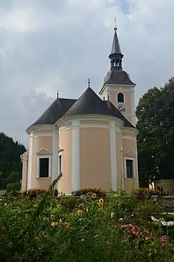 Mönichwald parish church | |
 Coat of arms | |
 Mönichwald Location within Austria | |
| Coordinates: 47°26′50″N 15°52′57″E / 47.44722°N 15.88250°E | |
| Country | Austria |
| State | Styria |
| District | Hartberg-Fürstenfeld |
| Area | |
• Total | 35.14 km2 (13.57 sq mi) |
| Elevation | 574 m (1,883 ft) |
| Population (1 January 2016)[1] | |
• Total | 864 |
| • Density | 25/km2 (64/sq mi) |
| Time zone | UTC+1 (CET) |
| • Summer (DST) | UTC+2 (CEST) |
| Postal code | 8252, 8251, 8253 |
| Area code | 03336 |
| Vehicle registration | HB |
| Website | www.moenichwald.at |
Mönichwald is a former municipality in the district of Hartberg-Fürstenfeld in Styria, Austria. Since the 2015 Styria municipal structural reform, it is part of the municipality of Waldbach-Mönichwald.[2]
References