Maar Shamarin
Maar Shamarin
معر شمارين | |
|---|---|
Village | |
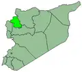
 Maar Shamarin Location in Syria | |
| Coordinates: 35°36′44″N 36°43′33″E / 35.61222°N 36.72583°E | |
| Country | |
| Governorate | Idlib |
| District | Maarrat al-Nu'man District |
| Subdistrict | Maarrat al-Nu'man Nahiyah |
| Population (2004) | |
• Total | 3,625 |
| Time zone | UTC+2 (EET) |
| • Summer (DST) | UTC+3 (EEST) |
| City Qrya Pcode | C3983 |
Maar Shamarin (Arabic: معر شمارين) is a Syrian village located in Maarrat al-Nu'man Nahiyah in Maarrat al-Nu'man District, Idlib. According to the Syria Central Bureau of Statistics (CBS), Maar Shamarin had a population of 3,625 in the 2004 census.[1]
History
According to an Ottoman Defter record from 1526, the village of Maar Shamarin had a population of 20 households all of whom were Muslim.[2]
References
- ^ "General Census of Population 2004". Retrieved 2015-12-09.
- ^ Nasiroğlu, Mehtap (2014-01-01). "XIV. yüzyılda Hama Sancağında kırsal yerleşme". Ankara Üniversitesi Dil ve Tarih-Coğrafya Fakültesi Tarih Bölümü Tarih Araştırmaları Dergisi: 144.