Maasbommel
Maasbommel | |
|---|---|
Small city | |
 | |
 Coat of arms | |
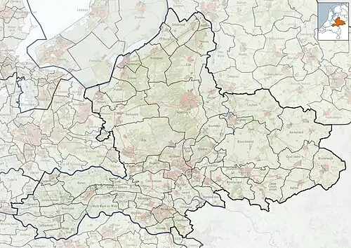 Maasbommel Location in the Netherlands  Maasbommel Maasbommel (Netherlands) | |
| Coordinates: 51°49′15″N 5°32′11″E / 51.82083°N 5.53639°E | |
| Country | Netherlands |
| Province | Gelderland |
| Municipality | West Maas en Waal |
| Area | |
• Total | 10.68 km2 (4.12 sq mi) |
| Elevation | 7 m (23 ft) |
| Population (2021)[1] | |
• Total | 1,345 |
| • Density | 130/km2 (330/sq mi) |
| Time zone | UTC+1 (CET) |
| • Summer (DST) | UTC+2 (CEST) |
| Postal code | 6627[1] |
| Dialing code | 0487 |
Maasbommel is a city in the Dutch province of Gelderland. It is a part of the municipality of West Maas en Waal, and lies about 7 km north of Oss. It received city rights in 1312.
Maasbommel was a separate municipality until 1818, when it was merged with Appeltern.[3]
History
It was first mentioned in 1144 as de Bumele, and probably means "forest of trees near the Maas" as to distinguish from Zaltbommel.[4] Maasbommel was established along the river.[5] In 1312, Maasbommel received city rights and joined the Hanseatic League.[6] Even though it was granted city rights, it did not develop after the Middle Ages.[5] In the 13th century, a church built which was demolished in 1812. In 1672, French troops severely damaged the city and destroyed the Hof bij Maasbommel.[7]
In 1818, Maasbommel was no longer an independent municipality and was merged into Appeltern.[7] In 1840, it was home to 703 people.[6] The Dutch Reformed Church dates from 1842, and the Catholic Church was built between 1868 and 1869.[5]
Maasbommel is known as the place where pioneering floating amphibious houses have been built.[8][9][10][11]
Gallery
-
 Church: the Sint-Lambertuskerk
 -
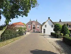
 Ruins of the Hof bij Maasbommel (1718–1730)
 -
.jpg) Harbour of Maasbommel
Harbour of Maasbommel -
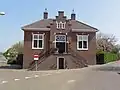 Former city hall
References
- ^ a b c "Kerncijfers wijken en buurten 2021". Central Bureau of Statistics. Retrieved 25 March 2022.
- ^ "Postcodetool for 6627AA". Actueel Hoogtebestand Nederland (in Dutch). Het Waterschapshuis. Archived from the original on 7 January 2019. Retrieved 25 March 2022.
- ^ Ad van der Meer and Onno Boonstra, Repertorium van Nederlandse gemeenten, KNAW, 2011.
- ^ "Maasbommel - (geografische naam)". Etymlologiebank (in Dutch). Retrieved 25 March 2022.
- ^ a b c Ronald Stenvert & Sabine Broekhoven (2000). "Maasbommel" (in Dutch). Zwolle: Waanders. ISBN 90 400 9406 3. Retrieved 25 March 2022.
- ^ a b "Maasbommel". Plaatsengids (in Dutch). Retrieved 25 March 2022.
- ^ a b A.G. Schulte (1986). Het Land van Maas en Waal (in Dutch). The Hague: Staatsuitgeverij. p. 284. ISBN 90 12 05040 5. Retrieved 25 March 2022.
- ^ Kroeger, Alix (2007-03-01). "Dutch pioneer floating eco-homes". BBC News. Retrieved 2010-07-21.
- ^ "Amphibious Houses: Dutch Answer to Flooding: Build Houses that Swim - SPIEGEL ONLINE - News - International". Spiegel.de. Retrieved 2010-07-21.
- ^ "From floating houses to rafts of hyacinths". Post Carbon Cities. 2007-11-26. Archived from the original on 2011-07-17. Retrieved 2010-07-21.
- ^ "Dutch Architects Plan for a Floating Future". NPR. Retrieved 2010-07-21.