Maengsan County
Maengsan County
맹산군 | |
|---|---|
| Korean transcription(s) | |
| • Chosŏn'gŭl | 맹산군 |
| • Hancha | 孟山郡 |
| • McCune-Reischauer | Maengsan-gun |
| • Revised Romanization | Maengsan-gun |
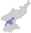
 Map of South Pyongan showing the location of Maengsan | |
| Country | North Korea |
| Province | South P'yŏngan |
| Administrative divisions | 1 ŭp, 24 ri |
| Area | |
• Total | 723.13 km2 (279.20 sq mi) |
| Population (2008[1]) | |
• Total | 48,155 |
| • Density | 67/km2 (170/sq mi) |
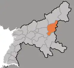
Maengsan County is a kun (county) in South P'yŏngan, North Korea.
Administrative districts
The district is split into one ŭp (town) and 24 ri (villages):
|
|
References
- ^ Korean Central Bureau of Statistics: 2008 Population Census Archived 2010-03-31 at the Wayback Machine (Population 2008, published in 2009)
External links
- (in English) Map of Pyongan provinces Archived 2012-03-11 at the Wayback Machine
- (in Korean) Detailed map