Maha Oya
| Maha Oya | |
|---|---|
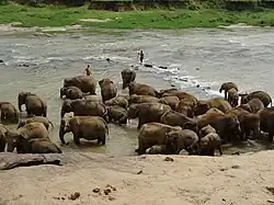 Maha Oya passes Pinnawala elephant orphanage area | |
 | |
| Physical characteristics | |
| Source | |
| • location | Nawalapitiya, Aranayake |
| Mouth | |
• location | Kochchikade, Negombo |
• coordinates | 07°16′21″N 79°50′34″E / 7.27250°N 79.84278°E |
• elevation | Sea level |
| Length | 134 km (83 mi) |
| Basin features | |
| Waterfalls | Asupini Ella |
| Bridges | Mawanella Bridge |
The Maha Oya (Sinhala: මහ ඔය, lit. 'Great River') is a major watercourse in the Sabaragamuwa Province of Sri Lanka. It measures approximately 134 km (83 mi) in length.[1] It runs across four provinces and five districts. The Maha Oya has 14 water supply networks to serve the need of water and more than 1 million people live by the river.[2]
Its catchment area receives approximately 3,644 million cubic metres of rain per year, and approximately 34 percent of the water reaches the sea. It has a catchment area of 1,510 square kilometres.[3]
See also
- List of dams and reservoirs in Sri Lanka
- List of rivers of Sri Lanka
- Maha Oya Pumped Storage Power Station
References
- ^ Yassin Mohammed, Essam (2013). Economic Incentives for Marine and Coastal Conservation: Prospects, Challenges and Policy Implications. Routledge. p. 296. ISBN 978-1-135-00663-1.
- ^ "Maha Oya Sand Mining To Affect Millions". Archived from the original on 20 July 2016. Retrieved 17 October 2016.
- ^ "Sri Lanka: Rivers". FAO. Retrieved 12 October 2016.