Mak Mandin
Mak Mandin | |
|---|---|
 | |
.svg.png) Mak Mandin | |
| Coordinates: 5°25′50.117″N 100°23′27.308″E / 5.43058806°N 100.39091889°E | |
| Country | |
| State | |
| City | |
| District | North Seberang Perai |
| Area | |
• Total | 2.9 km2 (1.1 sq mi) |
| Population (2020)[1] | |
• Total | 21,938 |
| • Density | 7,600/km2 (20,000/sq mi) |
| Demographics | |
| • Ethnic groups |
|
| Time zone | UTC+8 (MST) |
| • Summer (DST) | Not observed |
| Postal code | 134xx |
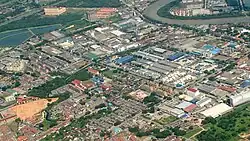
Mak Mandin is a suburb of Seberang Perai in the Malaysian state of Penang. There are Chinese, Tamil and National schools, a police station, a post office, a clinic and various light industrial factories which mainly produce foods, stationery, plastic bags and other consumer products.[2][3][4]
Geography
Map of Mak Mandin.
Click link at the top right corner to zoom in.
Click link at the top right corner to zoom in.
1
Kampung Baru2
Taman Baiduri3
Taman Mesra Permai4
Taman Segar5
Taman Tanjung IndahDemographics
As of 2020, Mukim 14, the subdivision that contains Mak Mandin, was home to a population of 21,938.[1] It was the most densely populated area within the city of Seberang Perai, with a population density of 7,565/km2 (19,590/sq mi). Ethnic Chinese comprised nearly 87% of the population, followed by Indians at 5%.
References
- ^ a b c d "MyCensus 2020: Mukim/Town/Pekan". Department of Statistics Malaysia. Putrajaya: 174–175. February 2024. ISBN 9789672537069.
- ^ "Maestro Swiss - Get in Touch".
- ^ "Campap".
- ^ "Fragstar".
Places adjacent to Mak Mandin | ||||||||||||||||
|---|---|---|---|---|---|---|---|---|---|---|---|---|---|---|---|---|
| ||||||||||||||||
Capital: George Town | |||||||||||||||||||||||||||||||
| Topics | |||||||||||||||||||||||||||||||
| Society | |||||||||||||||||||||||||||||||
| Administrative divisions |
| ||||||||||||||||||||||||||||||
| |||||||||||||||||||||||||||||||