Maloja Region
Maloja Region
| |
|---|---|
District | |
 Flag  Coat of arms | |
| Country | |
| Canton | Grisons |
| Area | |
• Total | 973.65 km2 (375.93 sq mi) |
| Population (2020) | |
• Total | 18,294 |
| • Density | 19/km2 (49/sq mi) |
| Time zone | UTC+1 (CET) |
| • Summer (DST) | UTC+2 (CEST) |
| Municipalities | 12 |
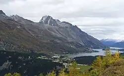
Maloja Region is one of the eleven administrative districts in the canton of Grisons in Switzerland. It has an area of 973.65 square kilometers (375.93 sq mi) and a population of 18,294 (as of 31 December 2020).[1] It was created on 1 January 2017 as part of a reorganization of the Canton.[2]
| Municipality | Population (31 December 2020)[1] |
Area (km2)[3] |
|---|---|---|
| Bever | 584 | 45.75 |
| Celerina/Schlarigna | 1,484 | 24.02 |
| Madulain | 206 | 16.28 |
| Pontresina | 2,178 | 118.2 |
| La Punt Chamues-ch | 686 | 63.28 |
| Samedan | 2,923 | 113.8 |
| St. Moritz | 4,945 | 28.69 |
| S-chanf | 697 | 138.04 |
| Sils im Engadin/Segl | 715 | 63.58 |
| Silvaplana | 1,121 | 44.77 |
| Zuoz | 1,199 | 65.79 |
| Bregaglia | 1,556 | 251.45 |
References
- ^ a b "Ständige und nichtständige Wohnbevölkerung nach institutionellen Gliederungen, Geburtsort und Staatsangehörigkeit". bfs.admin.ch (in German). Swiss Federal Statistical Office - STAT-TAB. 31 December 2020. Retrieved 21 September 2021.
- ^ Swiss Federal Statistical Office - Amtliches Gemeindeverzeichnis der Schweiz - Mutationsmeldungen 2016 accessed 16 February 2017
- ^ Arealstatistik Standard - Gemeindedaten nach 4 Hauptbereichen