Mangatano
Mangatano | |
|---|---|
 Mangatano Location in Madagascar | |
| Coordinates: 19°57′S 46°58′E / 19.950°S 46.967°E | |
| Country | |
| Region | Vakinankaratra |
| District | Antsirabe II |
| Elevation | 1,652 m (5,420 ft) |
| Population (2001)[2] | |
• Total | 8,000 |
| • Ethnicities | Merina |
| Time zone | UTC3 (EAT) |
Mangatano or Mangarano is a town and commune in Madagascar. It belongs to the district of Antsirabe II, which is a part of Vakinankaratra Region. The population of the commune was estimated to be approximately 8,000 in 2001 commune census.[2]
Primary and junior level secondary education are available in town. The majority 95% of the population of the commune are farmers, while an additional 5% receives their livelihood from raising livestock. The most important crops are rice and potatoes; also maize is an important agricultural product.[2]
References and notes
- ^ Estimated based on DEM data from Shuttle Radar Topography Mission
- ^ a b c "ILO census data". Cornell University. 2002. Retrieved 2008-04-22.
Capital: Antsirabe | ||
| Ambatolampy (19) | 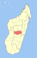 | |
| Antanifotsy (14) | ||
| Antsirabe I (1) | ||
| Antsirabe II (20) | ||
| Betafo (18) | ||
| Faratsiho (9) | ||
| Mandoto (9) | ||
7 districts; 89 communes | ||
19°57′S 46°58′E / 19.950°S 46.967°E