Mariahof
Mariahof | |
|---|---|
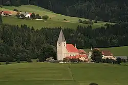 View with parish church | |
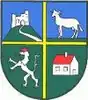 Coat of arms | |
 Mariahof Location within Austria | |
| Coordinates: 47°06′00″N 14°24′00″E / 47.10000°N 14.40000°E | |
| Country | Austria |
| State | Styria |
| District | Murau |
| Area | |
• Total | 32.7 km2 (12.6 sq mi) |
| Elevation | 963 m (3,159 ft) |
| Population (1 January 2016)[1] | |
• Total | 1,352 |
| • Density | 41/km2 (110/sq mi) |
| Time zone | UTC+1 (CET) |
| • Summer (DST) | UTC+2 (CEST) |
| Postal code | 8812, 8820 |
| Area code | 03584 |
| Vehicle registration | MU |
| Website | www.mariahof-steiermark.at |
Mariahof is a former municipality in the district of Murau in Styria, Austria. Since the 2015 Styria municipal structural reform, it is part of the municipality Neumarkt in der Steiermark.[2]
Geography
Mariahof lies in the valley of the Mur on the pass road between the Mur valley and the Metnitz valley.
References