Marigold, Illinois
Marigold, Illinois | |
|---|---|
 Marigold  Marigold | |
| Coordinates: 38°04′47″N 90°00′23″W / 38.07972°N 90.00639°W | |
| Country | United States |
| State | Illinois |
| County | Randolph |
| Elevation | 568 ft (173 m) |
| Time zone | UTC-6 (Central (CST)) |
| • Summer (DST) | UTC-5 (CDT) |
| Area code | 618 |
| GNIS feature ID | 422939[1] |
Marigold is an unincorporated community in Randolph County, Illinois, United States. The community is located on County Route 12 4.9 miles (7.9 km) east of Prairie du Rocher.[2]
References
- ^ "Marigold". Geographic Names Information System. United States Geological Survey, United States Department of the Interior.
- ^ Randolph County General Highway Map (PDF) (Map). Illinois Department of Transportation. June 17, 2016. Retrieved October 1, 2018.
Municipalities and communities of Randolph County, Illinois, United States | ||
|---|---|---|
| Cities | 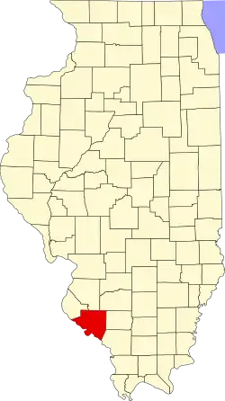 | |
| Villages | ||
| Precincts | ||
| Unincorporated communities | ||