Matalag River
Matalag River
| |
|---|---|
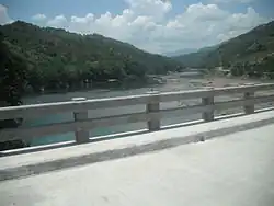 The Matalag River and with a view of Mount Maoanan | |
.svg.png) Matalag River mouth .svg.png) Matalag River (Philippines) | |
| Location | |
| Country | Philippines |
| Region | |
| Province | |
| Physical characteristics | |
| Source | |
| • location | Cordillera mountains |
| Mouth | Chico River |
• location | Rizal, Cagayan |
• coordinates | 17°49′55″N 121°27′54″E / 17.832049°N 121.465124°E |
| Length | 115 km (71 mi) |
| Basin size | 1,330 km2 (510 sq mi) |
| Basin features | |
| Progression | Matalag–Chico–Cagayan |
The Matalag River is a river in the Philippines flowing from the town of Kabugao in Apayao province to Rizal town in Cagayan province. It is a tributary of the Chico River, which later joins the Cagayan River,[2] the longest river in the country. The Isneg people settled within its area.[3]
References
- ^ Ethnography of the Major Ethnolinguistic Groups in the Cordillera. New Day Publishers. 2003. p. 92. ISBN 978-971-10-1109-3. Retrieved February 22, 2022.
- ^ Aluit, Alphonso J. (1990). The Philippines: Comprehensive, Authoritative, Up-to-date. Solar Publishing Company. p. 224. ISBN 978-971-17-0637-1. Retrieved February 22, 2022.
- ^ Prill-Brett, June (1987). A Survey of Cordillera Indigenous Political Institutions. Cordillera Studies Center, University of the Philippines College Baguio. p. 3. Retrieved February 22, 2022.