Maysville, Indiana
Maysville | |
|---|---|
 Maysville  Maysville | |
| Coordinates: 38°38′52″N 87°13′42″W / 38.64778°N 87.22833°W | |
| Country | United States |
| State | Indiana |
| County | Daviess |
| Township | Washington |
| Elevation | 440 ft (130 m) |
| ZIP code | 47501 |
| FIPS code | 18-47844[2] |
| GNIS feature ID | 438767[1] |
Maysville was an unincorporated town in Washington Township, Daviess County, Indiana. It was laid out in 1834 on the Wabash and Erie Canal, but disappeared when the canal ceased operations.[3]
References
- ^ a b U.S. Geological Survey Geographic Names Information System: Maysville, Indiana
- ^ "U.S. Census website". United States Census Bureau. Retrieved January 31, 2008.
- ^ History of Knox and Daviess County, Indiana: From the Earliest Time to the Present. Goodspeed. 1886. pp. 709.
Municipalities and communities of Daviess County, Indiana, United States | ||
|---|---|---|
| City | 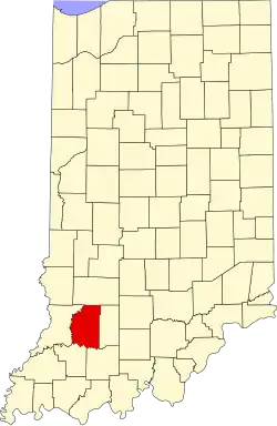 | |
| Towns | ||
| Townships | ||
| CDP | ||
| Other unincorporated communities | ||