McClave, Colorado
McClave, Colorado | |
|---|---|
 Entering McClave from the south (2013) | |
 McClave Location within Bent County and Colorado  McClave McClave (the United States) | |
| Coordinates: 38°07′54″N 102°51′02″W / 38.1315470°N 102.8504444°W[1] | |
| Country | United States |
| State | Colorado |
| County | Bent |
| Area | |
• Total | 1.914 sq mi (4.956 km2) |
| • Land | 1.914 sq mi (4.956 km2) |
| Elevation | 3,865 ft (1,178 m) |
| Population | |
• Total | 725 |
| • Density | 380/sq mi (150/km2) |
| Time zone | UTC−7 (MST) |
| • Summer (DST) | UTC−6 (MDT) |
| ZIP Code | 81057[4] |
| Area code | 719 |
| FIPS code | 08-08-47235 [1] |
| GNIS ID | 2805909 [1] |
McClave is an unincorporated community in Bent County, Colorado, United States.[1] The population was 725 at the 2020 census.[3]
History
The McClave post office has been in operation since 1908.[5] The town was named after B. I. McClave, a pioneer settler.[6] The McClave post office has the ZIP code 81057.[4]
McClave's services include a store, gas station, post office, and a K-12 school with a large athletic field.
Geography
The McClave CDP has an area of 1,225 acres (4.956 km2), all land.[2]
Climate
The Köppen Climate system classifies the weather as semi-arid, abbreviated as BSk.[7]
| Climate data for McClave, Colorado | |||||||||||||
|---|---|---|---|---|---|---|---|---|---|---|---|---|---|
| Month | Jan | Feb | Mar | Apr | May | Jun | Jul | Aug | Sep | Oct | Nov | Dec | Year |
| Mean daily maximum °C (°F) | 45 (7) |
51 (11) |
59 (15) |
70 (21) |
78 (26) |
89 (32) |
94 (34) |
92 (33) |
84 (29) |
72 (22) |
57 (14) |
46 (8) |
70 (21) |
| Mean daily minimum °C (°F) | 14 (−10) |
19 (−7) |
26 (−3) |
37 (3) |
47 (8) |
57 (14) |
63 (17) |
61 (16) |
51 (11) |
37 (3) |
24 (−4) |
16 (−9) |
38 (3) |
| Average precipitation mm (inches) | 0.4 (10) |
0.4 (10) |
0.8 (20) |
1.4 (36) |
2.3 (58) |
2.2 (56) |
2.4 (61) |
2.1 (53) |
1.2 (30) |
0.9 (23) |
0.5 (13) |
0.5 (13) |
15.3 (390) |
| Source: Weatherbase [8] | |||||||||||||
Demographics
The United States Census Bureau defined the McClave CDP for the United States Census 2020.
| Year | Pop. | ±% |
|---|---|---|
| 2020 | 725 | — |
| Source: United States Census Bureau | ||
See also
References
- ^ a b c d e "McClave, Colorado", Geographic Names Information System, United States Geological Survey, United States Department of the Interior
- ^ a b "State of Colorado Census Designated Places - BAS20 - Data as of January 1, 2020". United States Census Bureau. Retrieved December 8, 2020.
- ^ a b United States Census Bureau. "McClave CDP, Colorado". Retrieved April 9, 2023.
- ^ a b "Look Up a ZIP Code". United States Postal Service. Retrieved December 8, 2020.
- ^ "Post offices". Jim Forte Postal History. Retrieved July 1, 2016.
- ^ Dawson, John Frank. Place names in Colorado: why 700 communities were so named, 150 of Spanish or Indian origin. Denver, CO: The J. Frank Dawson Publishing Co. p. 34.
- ^ Climate Summary for McClave, Colorado
- ^ "Weatherbase.com". Weatherbase. 2013. Retrieved on September 5, 2013.
External links
Municipalities and communities of Bent County, Colorado, United States | ||
|---|---|---|
| City | 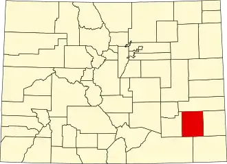 | |
| CDPs | ||
| Unincorporated communities | ||
| Fort | ||
| Ghost town | ||
| Footnotes | ‡This populated place also has portions in an adjacent county or counties | |