Mehoopany, Pennsylvania
Mehoopany, Pennsylvania | |
|---|---|
Unincorporated community | |
 Mehoopany | |
| Coordinates: 41°33′48″N 76°03′38″W / 41.56333°N 76.06056°W | |
| Country | United States |
| State | Pennsylvania |
| County | Wyoming |
| Elevation | 643 ft (196 m) |
| Time zone | UTC-5 (Eastern (EST)) |
| • Summer (DST) | UTC-4 (EDT) |
| ZIP code | 18629 |
| Area codes | 272 & 570 |
| GNIS feature ID | 1180870[1] |
Mehoopany is an unincorporated community in Wyoming County, Pennsylvania, United States.[1] The community is located along Pennsylvania Route 87, 3.6 miles (5.8 km) south of Meshoppen. Mehoopany has a post office with ZIP code 18629.[2][3]
Demographics
| Census | Pop. | Note | %± |
|---|
The United States Census Bureau defined Mehoopany as a census designated place (CDP) in 2023.[4]
References
- ^ a b "Mehoopany". Geographic Names Information System. United States Geological Survey, United States Department of the Interior.
- ^ United States Postal Service. "USPS - Look Up a ZIP Code". Retrieved August 15, 2017.
- ^ "Postmaster Finder - Post Offices by ZIP Code". United States Postal Service. Retrieved August 15, 2017.
- ^ "2023 Geography Changes". United States Census Bureau.
Municipalities and communities of Wyoming County, Pennsylvania, United States | ||
|---|---|---|
| Boroughs | 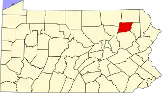 | |
| Townships | ||
| CDPs | ||
| Unincorporated communities | ||
| Ghost town | ||