Mesola
Mesola | |
|---|---|
| Comune di Mesola | |
 Mesola Castle | |
 Flag  Coat of arms | |
Location of Mesola | |
 Mesola Location of Mesola in Italy 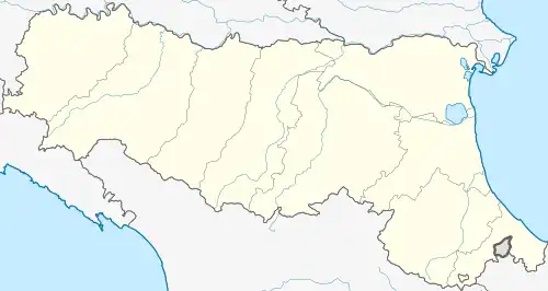 Mesola Mesola (Emilia-Romagna) | |
| Coordinates: 44°55′N 12°14′E / 44.917°N 12.233°E | |
| Country | Italy |
| Region | Emilia-Romagna |
| Province | Province of Ferrara (FE) |
| Area | |
• Total | 85 km2 (33 sq mi) |
| Elevation | 1 m (3 ft) |
| Population (30 April 2009)[2] | |
• Total | 7,223 |
| • Density | 85/km2 (220/sq mi) |
| Time zone | UTC+1 (CET) |
| • Summer (DST) | UTC+2 (CEST) |
| Postal code | 44026 |
| Dialing code | 0533 |
| Website | Official website |
Mesola (Ferrarese: La Mèsula) is a comune (municipality) in the Province of Ferrara in the Italian region Emilia-Romagna, located about 80 kilometres (50 mi) northeast of Bologna and about 50 kilometres (31 mi) east of Ferrara. As of 31 December 2004, it had a population of 7,331 and an area of 84.2 square kilometres (32.5 sq mi).[3]
Mesola borders the following municipalities: Ariano nel Polesine, Berra, Codigoro, Goro.
One of the landmarks in the town is the Castle of Mesola, built between 1578 and 1583, mainly used as a hunting lodge by the Este dynasty. It now houses the civic library and the Museum of the Wood and Deer of Mesola.[4]
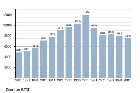
Demographic evolution
References
- ^ "Superficie di Comuni Province e Regioni italiane al 9 ottobre 2011". Italian National Institute of Statistics. Retrieved 16 March 2019.
- ^ "Popolazione Residente al 1° Gennaio 2018". Italian National Institute of Statistics. Retrieved 16 March 2019.
- ^ All demographics and other statistics: Italian statistical institute Istat.
- ^ Ferrara Terra e Acqua website, entry on castle.
External links