Mołstowa
| Mołstowa | |
|---|---|
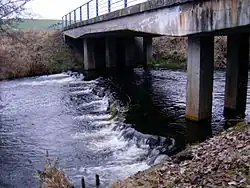 Mołstowa flowing through Bielikowo | |
| Location | |
| Country | |
| Voivodeship | West Pomeranian |
| Physical characteristics | |
| Source | |
| • location | north of Naćmierz, Łobez County |
| • coordinates | 53°44′43″N 15°36′03″E / 53.74528°N 15.60083°E |
| • elevation | 70 m (230 ft) |
| Mouth | Rega |
• location | west of Bielikowo, Gryfice County |
• coordinates | 53°59′11″N 15°17′39″E / 53.98639°N 15.29417°E |
• elevation | 7 m (23 ft) |
| Length | 48.9 km (30.4 mi) – 57 km (35 mi) |
| Basin size | 371.5 km2 (143.4 sq mi) – 377 km2 (146 sq mi) |
| Basin features | |
| Progression | Rega→ Baltic Sea |
Mołstowa is a river of Poland. It is a right-bank tributary of the Rega river[1] near Bielikowo.
In 2025, the ecosystem of the river was significantly damaged by non-permitted earthworks and heavy machinery use.[1]
References
- ^ a b "Interweniujemy w sprawie dewastacji brzegu rzeki Mołstowa - Portal Gov.pl" [Intervening in the case of the devastation of the Mołstova River bank]. Regionalny Zarząd Gospodarki Wodnej w Szczecinie (in Polish). Government of Poland. 29 May 2025. Retrieved 20 June 2025.