Moelfre Uchaf
| Moelfre Uchaf | |
|---|---|
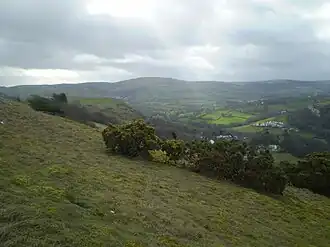 Moelfre Uchaf from Cefn-yr-Ogof | |
| Highest point | |
| Elevation | 396 m (1,299 ft) |
| Prominence | 144 m (472 ft) |
| Parent peak | Mwdwl-eithin |
| Listing | Sub-Marilyn |
| Coordinates | 53°13′48″N 3°39′08″W / 53.22997°N 3.65233°W |
| Naming | |
| English translation | High bare hill |
| Language of name | Welsh |
| Pronunciation | Welsh: [ˈmoilvrɛ ˈɪxav] |
| Geography | |
| Country | Wales |
| County Borough | Conwy |
| Parent range | Denbigh Moors |
| OS grid | SH898716 |
Moelfre Uchaf is a hill in Conwy County Borough, North Wales, 5 miles (8.0 km) south-east of Colwyn Bay and 1.5 mi (2.4 km) south-west of Betws-yn-Rhos. It is 396 m (1,299 ft) above sea level. A trigpoint is on the summit.
External links