Montchaton
Montchaton | |
|---|---|
Part of Orval-sur-Sienne | |
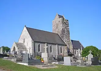 The church of Saint-Georges | |
Location of Montchaton | |
 Montchaton  Montchaton | |
| Coordinates: 49°00′34″N 1°29′50″W / 49.0094°N 1.4972°W | |
| Country | France |
| Region | Normandy |
| Department | Manche |
| Arrondissement | Coutances |
| Canton | Coutances |
| Commune | Orval-sur-Sienne |
Area 1 | 6.50 km2 (2.51 sq mi) |
| Population (2022)[1] | 309 |
| • Density | 48/km2 (120/sq mi) |
| Time zone | UTC+01:00 (CET) |
| • Summer (DST) | UTC+02:00 (CEST) |
| Postal code | 50660 |
| Elevation | 5–61 m (16–200 ft) (avg. 51 m or 167 ft) |
| 1 French Land Register data, which excludes lakes, ponds, glaciers > 1 km2 (0.386 sq mi or 247 acres) and river estuaries. | |
Montchaton (French pronunciation: [mɔ̃ʃatɔ̃]) is a former commune in the Manche department in Normandy in north-western France. On 1 January 2016, it was merged, together with the commune of Orval, into the new commune of Orval-sur-Sienne.[2]
Heraldry
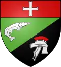 |
The arms of Montchaton are blazoned : Per bend sinister vert and sable, a salmon contourny 'leaping' and a roman helmet argent crested gules, and on a chief gules a cross moline argent.
|
See also
References
- ^ "Populations de référence 2022" [Reference populations 2022] (PDF) (in French). INSEE. December 2024.
- ^ Arrêté préfectoral 25 November 2015 (in French)
Wikimedia Commons has media related to Montchaton.