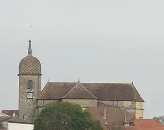
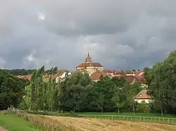
Montigny-lès-Cherlieu
Montigny-lès-Cherlieu | |
|---|---|
    | |
 Coat of arms | |
Location of Montigny-lès-Cherlieu | |
 Montigny-lès-Cherlieu  Montigny-lès-Cherlieu | |
| Coordinates: 47°47′59″N 5°48′44″E / 47.7997°N 5.8122°E | |
| Country | France |
| Region | Bourgogne-Franche-Comté |
| Department | Haute-Saône |
| Arrondissement | Vesoul |
| Canton | Jussey |
| Government | |
| • Mayor (2021–2026) | André Aubry[1] |
Area 1 | 20.98 km2 (8.10 sq mi) |
| Population (2022)[2] | 121 |
| • Density | 5.8/km2 (15/sq mi) |
| Time zone | UTC+01:00 (CET) |
| • Summer (DST) | UTC+02:00 (CEST) |
| INSEE/Postal code | 70362 /70500 |
| Elevation | 227–369 m (745–1,211 ft) |
| 1 French Land Register data, which excludes lakes, ponds, glaciers > 1 km2 (0.386 sq mi or 247 acres) and river estuaries. | |
Montigny-lès-Cherlieu (French pronunciation: [mɔ̃tiɲi lɛ ʃɛʁljø]) is a commune in the Haute-Saône department in the region of Bourgogne-Franche-Comté in eastern France.
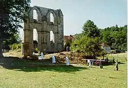
The Cistercian Cherlieu Abbey was sited here.
See also
References
- ^ "Répertoire national des élus: les maires". data.gouv.fr, Plateforme ouverte des données publiques françaises (in French). 9 August 2021.
- ^ "Populations de référence 2022" (in French). The National Institute of Statistics and Economic Studies. 19 December 2024.
Wikimedia Commons has media related to Montigny-lès-Cherlieu.