Montlaur, Aude
Montlaur | |
|---|---|
Part of Val-de-Dagne | |
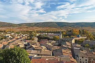 View of Montlaur | |
.svg.png) Coat of arms | |
Location of Montlaur | |
 Montlaur  Montlaur | |
| Coordinates: 43°07′50″N 2°33′31″E / 43.1306°N 2.5586°E | |
| Country | France |
| Region | Occitania |
| Department | Aude |
| Arrondissement | Carcassonne |
| Canton | La Montagne d'Alaric |
| Commune | Val-de-Dagne |
Area 1 | 33.92 km2 (13.10 sq mi) |
| Population (2021)[1] | 542 |
| • Density | 16/km2 (41/sq mi) |
| Time zone | UTC+01:00 (CET) |
| • Summer (DST) | UTC+02:00 (CEST) |
| Postal code | 11220 |
| Elevation | 135–552 m (443–1,811 ft) (avg. 208 m or 682 ft) |
| 1 French Land Register data, which excludes lakes, ponds, glaciers > 1 km2 (0.386 sq mi or 247 acres) and river estuaries. | |
Montlaur (French pronunciation: [mɔ̃lɔʁ] ⓘ) is a commune in the Aude department in southern France. On 1 January 2019, it was merged into the new commune Val-de-Dagne.[2]
Montlaur village is located in a valley delimited by the Alaric mountain in the North and the Coque hill in the South.
Population
| Year | Pop. | ±% |
|---|---|---|
| 1962 | 678 | — |
| 1968 | 713 | +5.2% |
| 1975 | 572 | −19.8% |
| 1982 | 534 | −6.6% |
| 1990 | 461 | −13.7% |
| 1999 | 522 | +13.2% |
| 2008 | 537 | +2.9% |
See also
References
- ^ "Populations légales 2021" [Legal populations 2021] (PDF) (in French). INSEE. December 2023.
- ^ Arrêté préfectoral 5 December 2018 (in French)
Wikimedia Commons has media related to Montlaur, Aude.