Moosthenning
Moosthenning | |
|---|---|
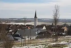 View towards Moosthenning | |
 Coat of arms | |
Location of Moosthenning within Dingolfing-Landau district 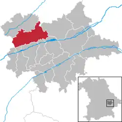 | |
 Moosthenning  Moosthenning | |
| Coordinates: 48°41′N 12°30′E / 48.683°N 12.500°E | |
| Country | Germany |
| State | Bavaria |
| Admin. region | Niederbayern |
| District | Dingolfing-Landau |
| Subdivisions | 6 Ortsteile |
| Government | |
| • Mayor (2020–26) | Anton Kargel[1] |
| Area | |
• Total | 70.40 km2 (27.18 sq mi) |
| Elevation | 368 m (1,207 ft) |
| Population (2024-12-31)[2] | |
• Total | 5,290 |
| • Density | 75/km2 (190/sq mi) |
| Time zone | UTC+01:00 (CET) |
| • Summer (DST) | UTC+02:00 (CEST) |
| Postal codes | 84164 |
| Dialling codes | 08731 |
| Vehicle registration | DGF |
| Website | www |
Moosthenning (Bavarian: Moosdenning) is a municipality in the district of Dingolfing-Landau in Bavaria in Germany.
References
- ^ Liste der ersten Bürgermeister/Oberbürgermeister in kreisangehörigen Gemeinden, Bayerisches Landesamt für Statistik, 15 July 2021.
- ^ "Gemeinden, Kreise und Regierungsbezirke in Bayern, Einwohnerzahlen am 31. Dezember 2024; Basis Zensus 2022" [Municipalities, counties, and administrative districts in Bavaria; Based on the 2022 Census] (CSV) (in German). Bayerisches Landesamt für Statistik.
Towns and municipalities in Dingolfing-Landau | ||
|---|---|---|