Morarano, Arivonimamo
Morarano | |
|---|---|
 Morarano Location in Madagascar | |
| Coordinates: 18°54′S 47°19′E / 18.900°S 47.317°E | |
| Country | |
| Region | Itasy |
| District | Arivonimamo |
| Elevation | 1,272 m (4,173 ft) |
| Population (2001)[2] | |
• Total | 13,000 |
| • Ethnicities | Merina |
| Time zone | UTC3 (EAT) |
Morarano is a town and commune in Madagascar. It belongs to the district of Arivonimamo, which is a part of Itasy Region. The population of the commune was estimated to be approximately 13,000 in 2001 commune census.[2]
Only primary schooling is available. The majority 99% of the population of the commune are farmers. The most important crop is rice, while other important products are maize, cassava and tomato. Services provide employment for 1% of the population.[2]
References and notes
- ^ Estimated based on DEM data from Shuttle Radar Topography Mission
- ^ a b c "ILO census data". Cornell University. 2002. Retrieved 2008-04-23.
Capital: Miarinarivo | ||
| Arivonimamo (22) - 112 | 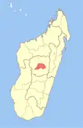 | |
| Miarinarivo (12) - 117 | ||
| Soavinandriana (15) - 118 | ||
3 districts; 49 communes | ||
18°54′S 47°19′E / 18.900°S 47.317°E