Mount Ashitaka
| Mount Ashitaka | |
|---|---|
 Southeast Side | |
| Highest point | |
| Peak | Mount Echizen-dake |
| Elevation | 1,504 m (4,934 ft)[1][2] |
| Listing | Volcanoes of Japan |
| Coordinates | 35°14′17″N 138°47′38″E / 35.238°N 138.7939°E[3] |
| Dimensions | |
| Length | 7 km (4.3 mi) Southwest-Northeast |
| Width | 6 km (3.7 mi) Northwest-Southeast |
| Naming | |
| Native name | 愛鷹山 (Japanese) |
| Geography | |
| Country | Japan |
| Prefecture | Shizuoka |
| Geology | |
| Volcanic arc | Izu–Bonin–Mariana Arc |
| Last eruption | Pleistocene[1] (extinct) |
 Ashitaka Mount Ashitaka (Japan) | |
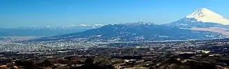
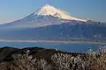
Mount Ashitaka (愛鷹山, Ashitakayama) is an eroded extinct stratovolcano in the area south-east of Mount Fuji, Japan. Its highest peak, 1,504 metres (4,934 ft) high,[4] is Mount Echizen-dake, but the complex is named after its secondary peak, Ashitaka-yama, 1,188 m (3,898 ft) high.
Detailed map
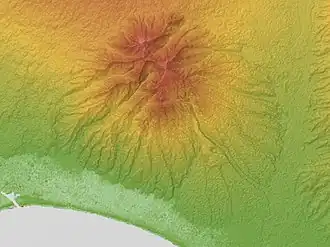
Topographic map of Ashitaka Volcano
Gallery
-
 From the south.
 -
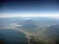 From above
 -
.jpg) From Mount Fuji
From Mount Fuji
See also
References
- ^ a b "Ashitaka". Global Volcanism Program. Smithsonian Institution. Retrieved 25 June 2021.
- ^ "Topographic map of Mount Ashitaka". opentopomap.org. Retrieved 15 June 2023.
- ^ "Ashitaka Yama". Geological Survey of Japan. Retrieved 15 June 2023.
- ^ Karátson, D (1999). "Erosion calderas: origins, processes, structural and climatic control". Bulletin of Volcanology. 61 (3): 179. Bibcode:1999BVol...61..174K. doi:10.1007/s004450050270.
The page incorporated material from Japanese Wikipedia page 愛鷹山, accessed 23 April 2019
External links
- Ashitaka Yama - Geological Survey of Japan