Mount Richardson (Canterbury)
| Mount Richardson | |
|---|---|
.png) Location in New Zealand | |
| Highest point | |
| Elevation | 1,047 m (3,435 ft) |
| Coordinates | 43°10′48″S 172°13′21″E / 43.1800°S 172.2226°E |
| Geography | |
| Location | South Island, New Zealand |
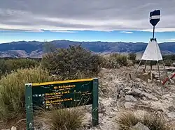
Mount Richardson is a 1,047 m (3,435 ft) high mountain in the Waimakariri District and Canterbury region of New Zealand, north of Oxford. It has a hiking trail that leads to the peak.[1][2] The Glentui River rises on its south-eastern slopes and the Ashley River / Rakahuri and its tributaries (of which the Glentui is one) drains the whole mountain.
Note and references
- ^ "Mount Richardson Description of the trail". Department of Conservation - Te Papa Atawhai. Retrieved 21 January 2021.
- ^ "Mt Richardson Loop, Mount Thomas Conservation Area, Canterbury NZ". Hiking Scenery. Retrieved 21 January 2021.