Mouriki
Mouriki
Μουρίκι | |
|---|---|
 Mouriki Location within the regional unit 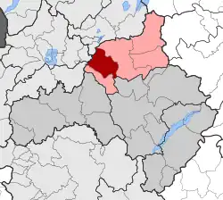 | |
| Coordinates: 40°29′N 21°34′E / 40.483°N 21.567°E | |
| Country | Greece |
| Administrative region | West Macedonia |
| Regional unit | Kozani |
| Municipality | Eordaia |
| Area | |
| • Municipal unit | 112.06 km2 (43.27 sq mi) |
| Elevation | 678 m (2,224 ft) |
| Population (2021)[1] | |
| • Municipal unit | 3,416 |
| • Municipal unit density | 30/km2 (79/sq mi) |
| Time zone | UTC+2 (EET) |
| • Summer (DST) | UTC+3 (EEST) |
| Vehicle registration | KZ |
Mouriki (Greek: Μουρίκι) is a former municipality in Kozani regional unit, West Macedonia, Greece. Since the 2011 local government reform it is part of the municipality Eordaia, of which it is a municipal unit.[2] The municipal unit has an area of 112.058 km2.[3] The population in 2021 was 3,416. The seat of the municipality was in Emporio.
References
- ^ "Αποτελέσματα Απογραφής Πληθυσμού - Κατοικιών 2021, Μόνιμος Πληθυσμός κατά οικισμό" [Results of the 2021 Population - Housing Census, Permanent population by settlement] (in Greek). Hellenic Statistical Authority. 29 March 2024.
- ^ "ΦΕΚ B 1292/2010, Kallikratis reform municipalities" (in Greek). Government Gazette.
- ^ "Population & housing census 2001 (incl. area and average elevation)" (PDF) (in Greek). National Statistical Service of Greece.