Muhlenberg Park, Pennsylvania
Muhlenberg Park, Pennsylvania | |
|---|---|
 Muhlenberg Park  Muhlenberg Park | |
| Coordinates: 40°23′05″N 75°56′29″W / 40.38472°N 75.94139°W | |
| Country | United States |
| State | Pennsylvania |
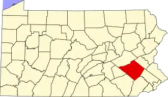
| County | Berks |
| Township | Muhlenberg |
| Area | |
• Total | 0.58 sq mi (1.50 km2) |
| • Land | 0.58 sq mi (1.50 km2) |
| • Water | 0.00 sq mi (0.00 km2) |
| Population | |
• Total | 1,544 |
| • Density | 2,662.07/sq mi (1,028.39/km2) |
| Time zone | UTC-5 (Eastern (EST)) |
| • Summer (DST) | UTC-4 (EDT) |
| ZIP code | 19605[3] |
| Area codes | 484 and 610 |
| FIPS code | 42-52216 |
Muhlenberg Park is a census-designated place[4] in Muhlenberg Township, Berks County, Pennsylvania, United States. The community is located just to the west of the borough of Laureldale. As of the 2010 census, the population was 1,420 residents.[4] Development of the community began in 1915.[5]
Demographics
| Census | Pop. | Note | %± |
|---|---|---|---|
| 2020 | 1,544 | — | |
| U.S. Decennial Census[6] | |||
References
- ^ "ArcGIS REST Services Directory". United States Census Bureau. Retrieved October 12, 2022.
- ^ "Census Population API". United States Census Bureau. Retrieved October 12, 2022.
- ^ "Muhlenberg Park PA ZIP Code". zipdatamaps.com. 2023. Retrieved May 13, 2023.
- ^ a b "US Census Bureau". Census.gov. Retrieved October 6, 2013.
- ^ https://www.muhlenbergtwp.com/DocumentCenter/View/233/Historical-PDF
- ^ "Census of Population and Housing". Census.gov. Retrieved June 4, 2016.