Municipality of Borovnica
Municipality of Borovnica
Občina Borovnica | |
|---|---|
 | |
 Coat of arms | |
 Location of the Municipality of Borovnica in Slovenia | |
| Coordinates: 45°54′N 14°23′E / 45.900°N 14.383°E | |
| Country | |
| Government | |
| • Mayor | Peter Crnilogar (Independent) |
| Area | |
• Total | 42.3 km2 (16.3 sq mi) |
| Elevation | 428 m (1,404 ft) |
| Population (2002)[1] | |
• Total | 3,839 |
| • Density | 91/km2 (240/sq mi) |
| Time zone | UTC+01 (CET) |
| • Summer (DST) | UTC+02 (CEST) |
| Postal code | 1353 |
| Vehicle registration | LJ |
| Website | www |
| Source: Statistical Office of the Republic of Slovenia, census of 2002. | |
The Municipality of Borovnica (Slovene: Občina Borovnica) is a municipality in the Inner Carniola region of Slovenia. The seat of the municipality is the settlement of Borovnica. The municipality is southwest of the national capital Ljubljana.[2]
History
In 2022, torrential rains caused locally extreme flooding in the Municipality of Borovnica.[3]
Settlements
In addition to the municipal seat of Borovnica, the municipality also includes the following settlements:
References
- ^ Statistical Office of the Republic of Slovenia, census of 2002
- ^ Borovnica municipal site
- ^ A. Č., K. S., M. B., STA (2022-09-16). "Gasilci na terenu, več vodotokov prestopa bregove". Delo (in Slovenian). eISSN 1854-6544. Archived from the original on 2025-03-24.
{{cite web}}: CS1 maint: multiple names: authors list (link)
External links
 Media related to Municipality of Borovnica at Wikimedia Commons
- Municipality of Borovnica on Geopedia
- Official page (in Slovene)
- Unofficial page - Forum (in Slovene)
| Settlements | 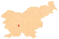 | |
|---|---|---|
| Landmarks | ||