Munnekeburen
Munnekeburen | |
|---|---|
Village | |
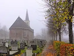 Munnekeburen Church | |
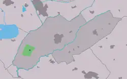 Location in Weststellingwerf municipality | |
 Munnekeburen Location in the Netherlands  Munnekeburen Munnekeburen (Netherlands) | |
| Coordinates: 52°50′55″N 5°53′9″E / 52.84861°N 5.88583°E | |
| Country | |
| Province | |
| Municipality | |
| Area | |
• Total | 7.88 km2 (3.04 sq mi) |
| Elevation | −0.3 m (−1.0 ft) |
| Population (2021)[1] | |
• Total | 455 |
| • Density | 58/km2 (150/sq mi) |
| Postal code | 8485[1] |
| Dialing code | 0561 |
Munnekeburen (West Frisian: Munnikebuorren) is a village in Weststellingwerf in the province of Friesland, the Netherlands. It had a population of around 430 in 2017.[3]
The village was first mentioned in 1243 as Monkeburen, and means monk neighbourhood. The monks were from the Saint Odulphus monastery in Stavoren.[4] Munnekeburen started as peat excavation settlement along the Padsloot.[5] The Dutch Reformed church was rebuilt in 1806.[6] It was extensively modified in 1860.[5]
Munnekeburen was home to 267 people in 1840, however that included a part of Langelille.[6]
References
- ^ a b c "Kerncijfers wijken en buurten 2021". Central Bureau of Statistics. Retrieved 2 April 2022.
two entries
- ^ "Postcodetool for 8485JA". Actueel Hoogtebestand Nederland (in Dutch). Het Waterschapshuis. Retrieved 2 April 2022.
- ^ Villages - Weststellingwerf municipality (in Dutch)
- ^ "Munnekeburen - (geografische naam)". Etymologiebank (in Dutch). Retrieved 2 April 2022.
- ^ a b Ronald Stenvert & Sabine Broekhoven (2000). "Munnekeburen" (in Dutch). Zwolle: Waanders. ISBN 90 400 9476 4. Retrieved 2 April 2022.
- ^ a b "Munnekeburen". Plaatsengids (in Dutch). Retrieved 2 April 2022.
External links
![]() Media related to Munnekeburen at Wikimedia Commons
Media related to Munnekeburen at Wikimedia Commons