Nacula
16°53′S 177°25′E / 16.883°S 177.417°E
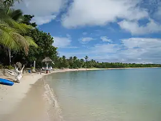 A beach on Nacula | |
| Geography | |
|---|---|
| Location | Pacific Ocean |
| Coordinates | 16°53′S 177°25′E / 16.883°S 177.417°E |
| Area | 21.7 km2 (8.4 sq mi) |
| Highest point | 243m |
| Administration | |
Fiji | |
| Demographics | |
| Population | 600 approx |
Nacula is a hilly and volcanic island of the Yasawa Group in Fiji's Ba Province.[1] It is the third-largest and is the second-farthest north in the group of islands.
There are 4 resorts on the island called Blue Lagoon Beach Resort, Safe Landing, Oarsman Bay Lodge and Nabua Lodge. Tourism is the main source of income on the island.
Nacula Island has 4 native villages, in descending order of size; Nacula village, Malakati village, Naisisili village and Navotua village.
The island's beaches have turquoise blue, gin-clear lagoons and are popular snorkeling and diving sites.
Gallery
-
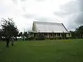 The local church on Nacula
References
- ^ Starnes, Dean; Nana Luckham (2009). Lonely Planet Fiji. Lonely Planet. p. 163. ISBN 978-1-74104-793-6. Retrieved 15 May 2010.
External links