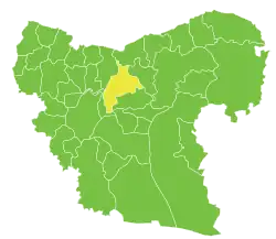
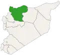
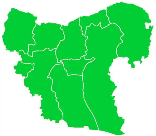
Al-Bab Subdistrict, also called Nahiya Markaz al-Bab (Arabic: ناحية مركز الباب), is a subdistrict of al-Bab District in northern Aleppo Governorate, northwestern Syria. Administrative centre is al-Bab. At the 2004 census, the subdistrict had a population of 112,219.[1]
Cities, towns and villages
Cities, towns and villages of Al-Bab Subdistrict
| PCode |
Name |
Population
|
| C1202 |
al-Bab |
63,069
|
| C1188 |
Bizaah |
12,718
|
| C1209 |
Qabasin |
11,382
|
| C1210 |
Maran |
3,670
|
| C1205 |
Tell Rahal |
2,866
|
| C1191 |
Hezwan |
1,579
|
| C1193 |
Maqri |
1,468
|
| C1187 |
Sosyan |
1,452
|
| C1200 |
Saflaniyeh |
1,353
|
| C1214 |
Qubbet Elsheikh |
1,274
|
| C1194 |
Aabad |
1,213
|
| C1197 |
Suran |
1,041
|
| C1190 |
Su Sinbat |
939
|
| C1211 |
Qdeiran |
850
|
| C1206 |
Shdud |
772
|
| C1189 |
Shaala |
757
|
| C1198 |
Hadath |
751
|
| C1204 |
Olan |
689
|
| C1199 |
Tal Jerji |
689
|
| C1213 |
Noman |
657
|
| C1196 |
Sheikh Elwan |
557
|
| C1195 |
Sheikh Jarrah |
535
|
| C1207 |
Sheikh Kif |
432
|
| C1186 |
Nayrabiyeh |
416
|
| C1208 |
Qemmet Daghelbash |
304
|
| C1203 |
Big Sarja |
237
|
| C1192 |
Borj |
236
|
| C1201 |
Um Elamad Elbab |
200
|
| C1212 |
Waqqah |
113
|
References
|
|---|
|
|
|---|
| Mount Simeon Subdistrict | |
|---|
| Tell ad-Daman Subdistrict |
- Tell al-Daman
- Abu Rweil
- Ameriyeh
- Arjel
- Atshana Sharqiya
- Atshana Gharbiya
- Ballas
- Ballas al-Jadida
- Batranah
- Burda
- Buwaida Saghira
- Deir Saliba
- Hmeidi
- Hober
- Jubb Aleis
- Kafr Obeid
- al-Mintar
- Mreiqes
- Oweinat Kabira
- Rasm al-Mofakker
- Tabara al-Khusheir
- Um al-Karamel
|
|---|
| Haritan Subdistrict | |
|---|
| Darat Izza Subdistrict |
- Darat Izza
- Bshantara
- Basrtun
- Bishqatin
- Kafrantin
- al-Hoteh
- Hur
- Injarah
- Irhab
- Qabtan al-Jabal
- al-Sakhriyah
- Taqad
|
|---|
| al-Hadher Subdistrict | |
|---|
| al-Zirbah Subdistrict |
- al-Zirbah
- Abad
- Arada
- Banes
- Barnah
- Barqum
- Bawabiyah
- Humayrah
- Huweir al-Eiss
- Jazraya
- Jubb Kas
- Kassibeh
- Othmaniya Kabira
- Rasm al-Eiss
- Talafeh
- Tell Allush
- Tell Hidyah
- Zitan
- Ziyara Samaan
|
|---|
| Zammar Subdistrict | |
|---|
|
| |
|
|
|---|
| Afrin Subdistrict | |
|---|
| Bulbul Subdistrict |
- Bulbul
- Burj Haider
- Darmashkanli
- Deir Ballut
- Fafertin
- Jalbul
- Karzahayel
|
|---|
| Jandairis Subdistrict | |
|---|
| Maabatli Subdistrict | |
|---|
| Rajo Subdistrict | |
|---|
| Sharran Subdistrict | |
|---|
| Shaykh al-Hadid Subdistrict | |
|---|
|
|
|
|
|
|
|---|
| Dayr Hafir Subdistrict | |
|---|
| Kuweires Sharqi Subdistrict | |
|---|
| Rasm Harmil al-Imam Subdistrict | |
|---|
|
|
|
|
|
|---|
| As-Safira Subdistrict | |
|---|
| Banan Subdistrict | |
|---|
| al-Hajib Subdistrict | |
|---|
| Khanasir Subdistrict | |
|---|
| Tell Aran Subdistrict | |
|---|
|
|