Nandlstadt
Nandlstadt | |
|---|---|
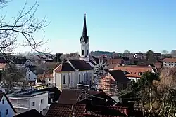 Church of Saint Martin | |
 Coat of arms | |
Location of Nandlstadt within Freising district 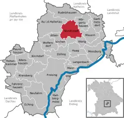 | |
 Nandlstadt  Nandlstadt | |
| Coordinates: 48°32′N 11°48′E / 48.533°N 11.800°E | |
| Country | Germany |
| State | Bavaria |
| Admin. region | Oberbayern |
| District | Freising |
| Government | |
| • Mayor (2020–26) | Gerhard Betz[1] |
| Area | |
• Total | 34.31 km2 (13.25 sq mi) |
| Elevation | 465 m (1,526 ft) |
| Population (2024-12-31)[2] | |
• Total | 5,635 |
| • Density | 160/km2 (430/sq mi) |
| Time zone | UTC+01:00 (CET) |
| • Summer (DST) | UTC+02:00 (CEST) |
| Postal codes | 85405 |
| Dialling codes | 08756 |
| Vehicle registration | FS |
| Website | www.markt-nandlstadt.de |
Nandlstadt is a municipality in the district of Freising in Bavaria in Germany. Nandlstadt is said to be the oldest hop-growing area in the world, having grown them since the year 860. The town lies in a triangle between Freising, Moosburg and Mainburg.
References
- ^ Liste der ersten Bürgermeister/Oberbürgermeister in kreisangehörigen Gemeinden, Bayerisches Landesamt für Statistik, 15 July 2021.
- ^ "Gemeinden, Kreise und Regierungsbezirke in Bayern, Einwohnerzahlen am 31. Dezember 2024; Basis Zensus 2022" [Municipalities, counties, and administrative districts in Bavaria; Based on the 2022 Census] (CSV) (in German). Bayerisches Landesamt für Statistik.
Towns and municipalities in Freising (district) | ||
|---|---|---|
 | ||