Nang, Leh
Nang | |
|---|---|
Village | |
 | |
 Nang Location in Ladakh, India  Nang Nang (India) | |
| Coordinates: 34°02′35″N 77°44′07″E / 34.043138°N 77.7351935°E | |
| Country | India |
| Union Territory | Ladakh |
| District | Leh |
| Tehsil | Leh |
| Elevation | 3,583 m (11,755 ft) |
| Population (2011) | |
• Total | 334 |
| Time zone | UTC+5:30 (IST) |
| 2011 census code | 857 |
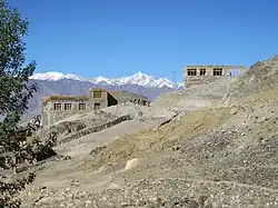
Nang is a village in the Leh district of Ladakh, India.[1] It is located in the Leh tehsil.
Demographics
According to the 2011 census of India, Nang has 74 households. The effective literacy rate (i.e. the literacy rate of population excluding children aged 6 and below) is 60.34%.[2]
| Total | Male | Female | |
|---|---|---|---|
| Population | 334 | 156 | 178 |
| Children aged below 6 years | 44 | 24 | 20 |
| Scheduled caste | 0 | 0 | 0 |
| Scheduled tribe | 333 | 156 | 177 |
| Literates | 175 | 94 | 81 |
| Workers (all) | 95 | 68 | 27 |
| Main workers (total) | 37 | 24 | 13 |
| Main workers: Cultivators | 3 | 2 | 1 |
| Main workers: Agricultural labourers | 0 | 0 | 0 |
| Main workers: Household industry workers | 0 | 0 | 0 |
| Main workers: Other | 34 | 22 | 12 |
| Marginal workers (total) | 58 | 44 | 14 |
| Marginal workers: Cultivators | 50 | 39 | 11 |
| Marginal workers: Agricultural labourers | 0 | 0 | 0 |
| Marginal workers: Household industry workers | 0 | 0 | 0 |
| Marginal workers: Others | 8 | 5 | 3 |
| Non-workers | 239 | 88 | 151 |
References
- ^ "Blockwise Village Amenity Directory" (PDF). Ladakh Autonomous Hill Development Council. Retrieved 23 July 2015.
- ^ a b "Leh district census". 2011 Census of India. Directorate of Census Operations. Retrieved 23 July 2015.
| State symbols | |||||||||||||||||||
|---|---|---|---|---|---|---|---|---|---|---|---|---|---|---|---|---|---|---|---|
| History |
| ||||||||||||||||||
| Administration | |||||||||||||||||||
| Geography |
| ||||||||||||||||||
| Human settlements | |||||||||||||||||||
| Culture |
| ||||||||||||||||||
| Tourism and wildlife |
| ||||||||||||||||||
| Transport |
| ||||||||||||||||||
| Infrastructure |
| ||||||||||||||||||
| See also |
| ||||||||||||||||||