Nemešany
Nemešany | |
|---|---|
 | |
 Flag | |
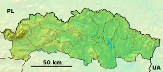 Nemešany Location of Nemešany in the Prešov Region  Nemešany Location of Nemešany in Slovakia | |
| Coordinates: 49°00′N 20°41′E / 49.00°N 20.68°E | |
| Country | |
| Region | |
| District | Levoča District |
| First mentioned | 1570 |
| Area | |
• Total | 4.01 km2 (1.55 sq mi) |
| Elevation | 462 m (1,516 ft) |
| Population (2021)[3] | |
• Total | 463 |
| Time zone | UTC+1 (CET) |
| • Summer (DST) | UTC+2 (CEST) |
| Postal code | 530 2[2] |
| Area code | +421 53[2] |
| Car plate | LE |
| Website | obecnemesany |
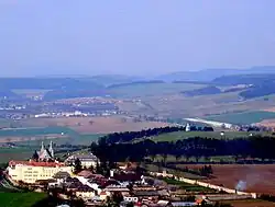
Nemešany (Hungarian: Nemessány) is a village and municipality in Levoča District in the Prešov Region of central-eastern Slovakia.
History
In historical records the village was first mentioned in 1570.
Geography
The municipality lies at an altitude of 482 metres and covers an area of 4 km2 (1.5 sq mi) (2020-06-30/-07-01).[4]
Population
It has a population of 426 people (2020-12-31).[5]
References
- ^ "Hustota obyvateľstva - obce [om7014rr_ukaz: Rozloha (Štvorcový meter)]". www.statistics.sk (in Slovak). Statistical Office of the Slovak Republic. 2022-03-31. Retrieved 2022-03-31.
- ^ a b c "Základná charakteristika". www.statistics.sk (in Slovak). Statistical Office of the Slovak Republic. 2015-04-17. Retrieved 2022-03-31.
- ^ "Počet obyvateľov podľa pohlavia - obce (ročne)". www.statistics.sk (in Slovak). Statistical Office of the Slovak Republic. 2022-03-31. Retrieved 2022-03-31.
- ^ "Statistic of Slovak places by Dušan Kreheľ – Export". Retrieved 2021-07-05.
- ^ "Statistic of Slovak places by Dušan Kreheľ – Export". Retrieved 2021-07-05.
Municipalities of Levoča District | ||
|---|---|---|