Nercha
| Nercha | |
|---|---|
 | |
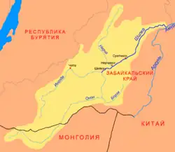 Shilka basin, including Nercha | |
| Location | |
| Country | Russia |
| Physical characteristics | |
| Source | Olyokma-Stanovik |
| Mouth | Shilka |
• coordinates | 51°55′01″N 116°38′28″E / 51.9169°N 116.6411°E |
| Length | 580 km (360 mi) |
| Basin size | 27,500 km2 (10,600 sq mi) |
| Basin features | |
| Progression | Shilka→ Amur→ Sea of Okhotsk |
| Nercha | |||||||
|---|---|---|---|---|---|---|---|
| Chinese name | |||||||
| Chinese | 尼布楚河 | ||||||
| |||||||
| Manchu name | |||||||
| Manchu script | Nibcu bira | ||||||
| Russian name | |||||||
| Russian | Нерча | ||||||
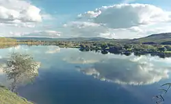
The Nercha (Russian: Нерча, Buryat: Нэршүү, Nershüü; Mongolian: Нэрчүү, Nerchüü) is a river in Zabaykalsky Krai in Russia, left tributary of the Shilka[1] (Amur's basin). The length of the river is 580 kilometres (360 mi). The area of its basin is 27,500 square kilometres (10,600 sq mi).[2] The Nercha freezes up in October and stays icebound until late April – early May. The town of Nerchinsk is located on the Nercha,[a] 7 kilometres (4 mi) from its confluence with the Shilka.
Notes
References
- ^ China Journal. China society of science and arts. 1923. p. 516. Retrieved June 8, 2019.
- ^ "Река Нерча in the State Water Register of Russia". textual.ru (in Russian).
- ^ Fu, L. (1966). A Documentary Chronicle of Sino-Western Relations, 1644-1820: Documentation and reference. A Documentary Chronicle of Sino-Western Relations, 1644-1820. Published for the Association for Asian Studies by the University of Arizona Press. p. 482. Retrieved June 8, 2019.