Nižné Nemecké
Nižné Nemecké
Alsónémeti | |
|---|---|
 Flag | |
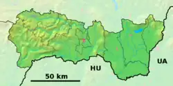 Nižné Nemecké Location of Nižné Nemecké in the Košice Region  Nižné Nemecké Location of Nižné Nemecké in Slovakia | |
| Coordinates: 48°39′N 22°15′E / 48.65°N 22.25°E | |
| Country | |
| Region | |
| District | Sobrance District |
| First mentioned | 1353 |
| Government | |
| • Mayor | Milan Husár (SNS) |
| Area | |
• Total | 7.25 km2 (2.80 sq mi) |
| Elevation | 115 m (377 ft) |
| Population (2021)[3] | |
• Total | 310 |
| Time zone | UTC+1 (CET) |
| • Summer (DST) | UTC+2 (CEST) |
| Postal code | 725 2[2] |
| Area code | +421 56[2] |
| Car plate | SO |
| Website | www |
Nižné Nemecké (Hungarian: Alsónémeti) is a village and municipality in the Sobrance District in the Košice Region of east Slovakia. The name of the village literally means "Germans of the lower" e.g. German women/things living/positioned in a lower area/village, where Germans is an adjective in the feminine or neuter gender.
History
In historical records the village was first mentioned in 1353. During the Slovak-Hungarian War this village was a target of shelling and bombing by Hungarian forces.
Geography
The village lies at an altitude of 110 metres and covers an area of 7.246 km². It has a population of 333 people.
Culture
The village has a library and a soccer pitch.
References
- ^ "Hustota obyvateľstva - obce [om7014rr_ukaz: Rozloha (Štvorcový meter)]". www.statistics.sk (in Slovak). Statistical Office of the Slovak Republic. 31 March 2022. Retrieved 31 March 2022.
- ^ a b c "Základná charakteristika". www.statistics.sk (in Slovak). Statistical Office of the Slovak Republic. 17 April 2015. Retrieved 31 March 2022.
- ^ "Počet obyvateľov podľa pohlavia - obce (ročne)". www.statistics.sk (in Slovak). Statistical Office of the Slovak Republic. 31 March 2022. Retrieved 31 March 2022.