Niagara Peak
| Niagara Peak | |
|---|---|
 North face | |
| Highest point | |
| Elevation | 13,812 ft (4,210 m)[1][2] |
| Prominence | 567 ft (173 m)[3] |
| Isolation | 0.63 mi (1.01 km)[3] |
| Coordinates | 37°53′21″N 107°32′01″W / 37.8892927°N 107.5335123°W[1] |
| Geography | |
 Niagara Peak | |
| Location | Hinsdale and San Juan counties, Colorado, U.S.[4] |
| Parent range | San Juan Mountains[3] |
| Topo map(s) | USGS 7.5' topographic map Handies Peak, Colorado[1] |
Niagara Peak is a high mountain summit in the San Juan Mountains range of the Rocky Mountains System, in southwestern Colorado.
The 13,812-foot (4,210 m) thirteener is located 8.9 miles (14.4 km) northeast by east (bearing 53°) of the Town of Silverton, on the Continental Divide between Hinsdale and San Juan counties.[1][2][3][4]
Climate
According to the Köppen climate classification system, Niagara Peak has an alpine climate with cold, snowy winters, and cool to warm summers.[5] Due to its altitude, it receives precipitation all year, as snow in winter and as thunderstorms in summer, with a dry period in late spring.
See also
- List of Colorado mountain summits
- List of the most prominent summits of Colorado
- List of Colorado county high points
Gallery
-
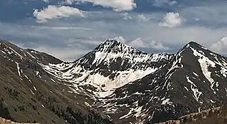
 North aspect
 -
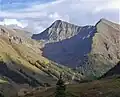
 North face, upper left corner
 -
 Niagara Peak to right of center.
References
- ^ a b c d "NIAGARA". NGS Data Sheet. National Geodetic Survey, National Oceanic and Atmospheric Administration, United States Department of Commerce. Retrieved November 4, 2014.
- ^ a b The elevation of Niagara Peak includes an adjustment of +1.942 m (+6.37 ft) from NGVD 29 to NAVD 88.
- ^ a b c d "Niagara Peak, Colorado". Peakbagger.com. Retrieved November 4, 2014.
- ^ a b "Niagara Peak". Geographic Names Information System. United States Geological Survey, United States Department of the Interior. Retrieved November 4, 2014.
- ^ Peel, M. C.; Finlayson, B. L.; McMahon, T. A. (2007). "Updated world map of the Köppen−Geiger climate classification". Hydrol. Earth Syst. Sci. 11. ISSN 1027-5606.
External links
Denver (capital) | |
| Topics |
|
| Society | |
| Cities |
|
| Counties |
|
| Regions |
|