Nogvafjord Tunnel
 Map of the Nordøyvegen road network | |
| Overview | |
|---|---|
| Location | Møre og Romsdal, Norway |
| Coordinates | 62°40′53″N 6°20′15″E / 62.68139°N 6.33753°E |
| Status | In use |
| Route | |
| Start | Skuløya |
| End | Fjørtofta |
| Operation | |
| Opened | 27 Aug 2022 |
| Operator | Statens vegvesen |
| Technical | |
| Length | 5,730 metres (3.56 mi) |
| Lowest elevation | 134 metres (440 ft) |
| Grade | 7% |
| Route map | |
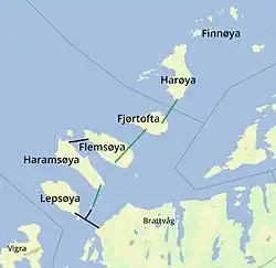
The Nogvafjord Tunnel (Norwegian: Nogvafjordtunnelen) is an undersea road tunnel in Haram Municipality in Møre og Romsdal county, Norway. The tunnel connects the island of Fjørtofta to the island of Skuløya. The 5,730-metre (3.56 mi) long tunnel opened on 27 August 2022 and it reaches a depth of 134 metres (440 ft) below sea level. It is part of Norwegian County Road 659 and the Nordøyvegen road network.[1][2]
References
- ^ Kjerstad, Norvald, ed. (21 April 2025). "Nordøyvegen". Store norske leksikon (in Norwegian). Foreningen Store norske leksikon. Retrieved 26 April 2025.
- ^ "Heile Nordøyvegen opnar 27. august 2022" (in Norwegian). 1 July 2021. Archived from the original on 9 October 2021.