Noiron-sur-Seine
Noiron-sur-Seine | |
|---|---|
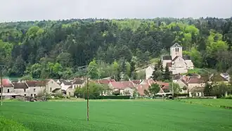 A general view of Noiron-sur-Seine | |
.svg.png) Coat of arms | |
Location of Noiron-sur-Seine | |
 Noiron-sur-Seine  Noiron-sur-Seine | |
| Coordinates: 47°56′53″N 4°29′12″E / 47.9481°N 4.4867°E | |
| Country | France |
| Region | Bourgogne-Franche-Comté |
| Department | Côte-d'Or |
| Arrondissement | Montbard |
| Canton | Châtillon-sur-Seine |
| Intercommunality | Pays Châtillonnais |
| Government | |
| • Mayor (2020–2026) | Florent Chodat[1] |
Area 1 | 11.38 km2 (4.39 sq mi) |
| Population (2022)[2] | 59 |
| • Density | 5.2/km2 (13/sq mi) |
| Time zone | UTC+01:00 (CET) |
| • Summer (DST) | UTC+02:00 (CEST) |
| INSEE/Postal code | 21460 /21400 |
| Elevation | 192–347 m (630–1,138 ft) (avg. 352 m or 1,155 ft) |
| 1 French Land Register data, which excludes lakes, ponds, glaciers > 1 km2 (0.386 sq mi or 247 acres) and river estuaries. | |
Noiron-sur-Seine (French pronunciation: [nwaʁɔ̃ syʁ sɛn], literally Noiron on Seine) is a commune in the Côte-d'Or department in eastern France.
Population
| Year | Pop. | ±% |
|---|---|---|
| 1962 | 115 | — |
| 1968 | 131 | +13.9% |
| 1975 | 114 | −13.0% |
| 1982 | 109 | −4.4% |
| 1990 | 98 | −10.1% |
| 1999 | 91 | −7.1% |
| 2008 | 85 | −6.6% |
See also
References
- ^ "Répertoire national des élus: les maires" (in French). data.gouv.fr, Plateforme ouverte des données publiques françaises. 13 September 2022.
- ^ "Populations de référence 2022" (in French). The National Institute of Statistics and Economic Studies. 19 December 2024.
Wikimedia Commons has media related to Noiron-sur-Seine.