Norfeld Colony, South Dakota
Norfeld Colony, South Dakota | |
|---|---|
 Norfeld Colony  Norfeld Colony | |
| Coordinates: 44°25′24″N 96°33′22″W / 44.42333°N 96.55611°W | |
| Country | United States |
| State | South Dakota |
| County | Brookings |
| Area | |
• Total | 0.50 sq mi (1.29 km2) |
| • Land | 0.50 sq mi (1.29 km2) |
| • Water | 0.00 sq mi (0.00 km2) |
| Elevation | 1,936 ft (590 m) |
| Population | |
• Total | 9 |
| • Density | 18.07/sq mi (6.98/km2) |
| Time zone | UTC-6 (Central (CST)) |
| • Summer (DST) | UTC-5 (CDT) |
| ZIP Code | 57276 (White) |
| Area code | 605 |
| FIPS code | 46-45390 |
| GNIS feature ID | 2807095[2] |
Norfeld Colony is a Hutterite colony[4] and census-designated place (CDP) in Brookings County, South Dakota, United States. It was first listed as a CDP prior to the 2020 census.[2] The population of the CDP was 9 at the 2020 census.[5]
It is in the northeast part of the county, 5 miles (8 km) east of White and 19 miles (31 km) northeast of Brookings, the county seat.
Demographics
| Census | Pop. | Note | %± |
|---|---|---|---|
| 2020 | 9 | — | |
| U.S. Decennial Census[6] | |||
References
- ^ "ArcGIS REST Services Directory". United States Census Bureau. Retrieved October 15, 2022.
- ^ a b c U.S. Geological Survey Geographic Names Information System: Norfeld Colony, South Dakota
- ^ "Census Population API". United States Census Bureau. Retrieved October 15, 2022.
- ^ Friesen, Bert (May 2021). "Norfeld Hutterite Colony (White, South Dakota, USA)". Global Anabaptist Mennonite Encyclopedia Online. Retrieved September 10, 2021.
- ^ "U.S. Census Bureau: Norfeld Colony CDP, South Dakota". www.census.gov. United States Census Bureau. Retrieved February 20, 2022.
- ^ "Census of Population and Housing". Census.gov. Retrieved June 4, 2016.
Municipalities and communities of Brookings County, South Dakota, United States | ||
|---|---|---|
| Cities | 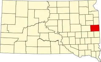 | |
| Towns | ||
| CDPs | ||
| Other communities | ||
| Townships |
| |
| Footnotes | ‡This populated place also has portions in an adjacent county or counties | |