Northwest Italy
Northwest Italy
| |
|---|---|
 | |
| Country | Italy |
| Regions | |
| Area | |
• Total | 57,950 km2 (22,370 sq mi) |
| Population (2025)[1] | |
• Total | 15,923,805 |
| • Density | 270/km2 (710/sq mi) |
| Languages | |
| – Official language | Italian |
| – Official linguistic minorities[2] | |
| – Regional languages | |
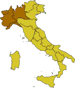
Northwest Italy (Italian: Italia nord-occidentale or just Nord-ovest) is one of the five official statistical regions of Italy used by the National Institute of Statistics (ISTAT), a first level NUTS region and a European Parliament constituency. Northwest encompasses four of the country's 20 regions:
Geography
It borders to the west with France via the Western Alps, to the north with Switzerland via the Central Alps, to the east with the regions of Trentino-Alto Adige, Veneto and Emilia-Romagna belonging to Northeast Italy and to the south with the Ligurian Sea and the extreme offshoot of Tuscany in Central Italy. Northwest Italy includes a large part of the Po Valley and is crossed by the Po river, the longest in Italy.
Demography
Northwest Italy has 15,923,805 inhabitants as of 2025.[1]
|
| ||||||||||||||||||||||||||||||||||||||||||||||||||||||
| Source: ISTAT[3][4] | |||||||||||||||||||||||||||||||||||||||||||||||||||||||
Regions
| Region | Capital | Inhabitants | Area
(km²) |
Density
(inh./km²) |
|---|---|---|---|---|
| Aosta | 122,714 | 3,263 | 38 | |
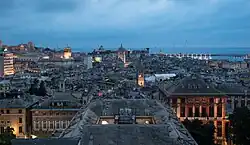
| Genoa | 1,509,908 | 5,422 | 278 | |
| Milan | 10,035,481 | 23,844 | 420 | |
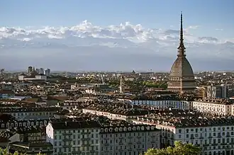
| Turin | 4,255,702 | 25,402 | 167 |
Most populous municipalities


Below is the list of the most populous municipalities with more than 50,000 inhabitants:[5]
| # | Municipality | Region | Inhabitants |
|---|---|---|---|
| 1 | Milan | 1,366,155 | |
| 2 | Turin | 856,745 | |
| 3 | Genoa | 563,947 | |
| 4 | Brescia | 199,949 | |
| 5 | Monza | 123,131 | |
| 6 | Bergamo | 120,580 | |
| 7 | Novara | 102,573 | |
| 8 | La Spezia | 92,711 | |
| 9 | Alessandria | 92,518 | |
| 10 | Busto Arsizio | 83,995 | |
| 11 | Como | 83,228 | |
| 12 | Varese | 79,018 | |
| 13 | Sesto San Giovanni | 78,843 | |
| 14 | Cinisello Balsamo | 74,847 | |
| 15 | Asti | 73,503 | |
| 16 | Pavia | 71,556 | |
| 17 | Cremona | 71,062 | |
| 18 | Vigevano | 62,845 | |
| 19 | Legnano | 60,646 | |
| 20 | Savona | 58,690 | |
| 21 | Cuneo | 55,804 | |
| 22 | Moncalieri | 55,489 | |
| 23 | Sanremo | 53,033 | |
| 24 | Gallarate | 52,886 | |
| 25 | Rho | 50,831 |
Economy
The gross domestic product (GDP) of the region was 580.3 billion euro in 2018, accounting for 32.9% of Italy's economic output. GDP per capita adjusted for purchasing power was 35,900 euro or 119% of the EU27 average in the same year.[6]
See also
- National Institute of Statistics (Italy)
- NUTS statistical regions of Italy
- Italian NUTS level 1 regions:
- Northern Italy
- Central Italy
- Southern Italy
References
- ^ a b "Monthly Demographic Balance". ISTAT.
- ^ "Legge 482". Webcitation.org. Archived from the original on 24 September 2015. Retrieved 17 October 2015.
- ^ "Popolazione residente e presente dei comuni. Censimenti dal 1861 al 1971" [Resident and present population of the municipalities. Censuses from 1861 to 1971] (PDF) (in Italian). ISTAT. 24 October 1971.
- ^ "Dashboard Permanent census of population and housing". ISTAT.
- ^ Cite error: The named reference
population2was invoked but never defined (see the help page). - ^ "Regional GDP per capita ranged from 30% to 263% of the EU average in 2018". Eurostat.
45°30′N 9°00′E / 45.500°N 9.000°E