Norvegia Point
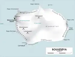
Norvegia Point (Norwegian: Kapp Norvegia), (54°27′S 3°21′E / 54.450°S 3.350°E) is a point 2 nautical miles (3.7 km) south of Cape Circoncision on the west side of Bouvet Island. First roughly charted from the Valdivia in 1898 by a German expedition under Carl Chun. Recharted in December 1927 by a Norwegian expedition under Captain Harald Horntvedt. Named by Horntvedt after his expedition ship, the Norvegia I.[1][2]
See also
References
- ^ "Prof. Dr. phil., Dr. med. h. c. Carl Chun". University of Leipzig. Retrieved October 1, 2016.
- ^ "Norvegia I". polarhistorie.no. Archived from the original on 2011-02-06. Retrieved October 1, 2016.
![]() This article incorporates public domain material from "Norvegia Point". Geographic Names Information System. United States Geological Survey.
This article incorporates public domain material from "Norvegia Point". Geographic Names Information System. United States Geological Survey.