Nullawil
| Nullawil Victoria | |||||||||||||||
|---|---|---|---|---|---|---|---|---|---|---|---|---|---|---|---|
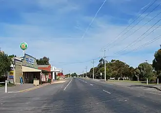 Calder Highway passing through Nullawil, 2012 | |||||||||||||||
 Nullawil | |||||||||||||||
| Coordinates | 35°51′0″S 143°11′0″E / 35.85000°S 143.18333°E | ||||||||||||||
| Population | 92 (2021 census)[1] | ||||||||||||||
| Postcode(s) | 3529 | ||||||||||||||
| Location |
| ||||||||||||||
| LGA(s) | Shire of Buloke | ||||||||||||||
| State electorate(s) | Mildura | ||||||||||||||
| Federal division(s) | Mallee | ||||||||||||||
| |||||||||||||||
Nullawil is a town in Victoria, Australia, located approximately 302 kilometres (188 mi) from the state capital, Melbourne. At the 2021 census, Nullawil had a population of 92.[1]
It is thought that the name of the settlement derives from two Aboriginal words: "nulla", meaning killing stick, and "wil", from "willock", meaning galah.[2]
The railway came to Nullawil in March 1895, when the line was extended from Wycheproof to Sea Lake.[3] Passenger services ceased in May 1977. The post office opened on 26 April 1897.[4]
Gallery
-
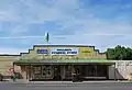 General store, 2012
 -
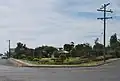 Town park, 2012
 -
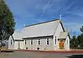 St Joseph's Catholic Church, 2012
References
Wikimedia Commons has media related to Nullawil.
- ^ a b Australian Bureau of Statistics (28 June 2022). "Nullawil (Suburbs and Localities)". 2021 Census QuickStats. Retrieved 13 November 2022.
- ^ "Nullawil, Smug". Silo Art Trail. Retrieved 19 October 2023.
- ^ "Nullawil". Vicsig. Retrieved 19 October 2023.
- ^ Phoenix Auctions History. "Post Office List". Retrieved 29 March 2021.
Localities in the Shire of Buloke | ||
|---|---|---|
| Town | | |
| Locality |
| |
^ - Territory divided with another LGA | ||