Nura District
Nura | |
|---|---|
District | |
| Нұра ауданы | |
 Coat of arms | |
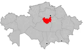 | |
| Country | Kazakhstan |
| Region | Karaganda Region |
| Administrative center | Nura |
| Founded | 1928 |
| Government | |
| • Akim | Zhusup Zhumagulov[1] |
| Population (2019)[2] | |
• Total | 22,569 |
| Time zone | UTC+6 (East) |
Nura District (Kazakh: Нұра ауданы, Nūra audany) is a district of Karaganda Region in central Kazakhstan. The administrative center of the district is the settlement of Nura.[3] The district has a population of 22,569 as of 2019.[2]
Geography
The district is located in the Kazakh Uplands. Rivers Kulanotpes and Sonaly, and lakes Kerey, Kypshak, Kiyakty and Shoshkakol are located in the district.[4]
History
During the 1890s, a number of Ukrainians, Russians, and Germans began constructing settlements in the area, which was already home to approximately 330 villages of the native Kazakh people.[5] On April 19, 1923, by order of the Kirghiz SSR, the Nurinsk Volost was created as part of the Akmola Uyezd.[5] On March 10, 1932, the Nurinsk Volost joined the newly created Karagandy Oblast.[5] Nura became the district's administrative center in 1928.[5]
The 1930s saw a number of modernization programs implemented in the district, with electricity, telephones, and postal services being introduced.[5] 16 schools were erected as part of a wider Soviet program to combat illiteracy known as likbez.[5]
During World War II, over 3,000 people from the district fought in the war, and 1,083 died in battle.[5] Two residents of the district were awarded the Hero of the Soviet Union medal.[5]
From 1954 to 1957, 7 state farms were created in the district as part of the Virgin Lands Program.[5]
Demographics
| Year | Pop. | ±% |
|---|---|---|
| 1999 | 38,649 | — |
| 2009 | 26,150 | −32.3% |
| 2019 | 22,569 | −13.7% |
Nura has suffered considerable population decline in post-Soviet times, with population falling from 38,649 (1999 census results)[6], down to 26,150 (2009 census results)[6], to 22,569 as of 2019.[2]
Ethnic composition
| Ethnic Group | Population (2019) | Percent of Total |
|---|---|---|
| Kazakhs | 15,250 | 67.57% |
| Russians | 3,901 | 17.28% |
| Ukrainians | 1,286 | 5.70% |
| Germans | 927 | 4.11% |
| Belarusians | 377 | 1.67% |
| Tatars | 305 | 1.35% |
| Chechens | 55 | 0.24% |
| Mordvins | 50 | 0.22% |
| Azeris | 49 | 0.22% |
| Moldovans | 45 | 0.20% |
| Chuvash | 44 | 0.19% |
| Bashkirs | 42 | 0.19% |
| Lithuanians | 42 | 0.19% |
| Poles | 41 | 0.18% |
| Koreans | 32 | 0.14% |
| Uzbeks | 11 | 0.05% |
| Greeks | 5 | 0.02% |
| Others | 107 | 0.47% |
| Total | 22,569 | 100.00% |
Administrative divisions
| Rural district/city | Population (2021) | Settlement(s) |
|---|---|---|
| Nura Rural Administration | 6626 | Nura |
| Kobetei Rural District | 1302 | Kobetei, Ondiris, Pervoe Maya |
| Ahmet Rural District | 1221 | Ahmet |
| Shubarkol Rural District | 1142 | Shubarkol |
| Kyzyltal Rural District | 1036 | Kertindi, Algabas |
| Tassuat Rural District | 994 | Kainar |
| Egindi Rural District | 993 | Egindi |
| Shahter Rural District | 983 | Shahterskoe |
| Baitugan Rural District | 938 | Baitugan, Zhanakurylys |
| Zarechnyi Rural District | 871 | Zarechnoe |
| Korganzhar Rural District | 801 | Karim Mynbaev |
| Industrialnyi Rural District | 696 | Tassuat |
| Muzbel Rural District | 647 | Muzbel |
| Barshin Rural District | 641 | Barshino, Bestamak |
| Akmeshit Rural District | 614 | Akmeshit, Kantai |
| Kenzharyk Rural District | 548 | Izendi, Kenzharyk, Toparkol |
| Karaoi Rural District | 511 | Karaoi |
| Zharaspai Rural District | 394 | Zharaspai |
| Karakoiyn Rural District | 381 | Zhanbobek, Akkolka |
| Kulanotpes Rural District | 336 | Kulanotpes, Aktubek, Nygman |
| Don Rural District | 304 | Kulanotpes |
| Saryozen Rural District | 202 | Tikenekti |
| Balyktykol Rural District | 192 | Balyktykol |
| Taldysai Rural District | 160 | Taldysai |
| Sonaly Rural District | 122 | Sonaly |
Notable people
- Nikolai Alexeyevich Kuznetsov, Soviet aviator
References
- ^ "Akims of Nur and Saryarka districts appointed in Astana". kazpravda.kz. 2023-04-12.
- ^ a b c d Численность населения Республики Казахстан по отдельным этносам на начало 2019 года. Комитет по статистике Министерства национальной экономики Республики Казахстан (in Kazakh). Archived from the original on 2020-06-04. Retrieved 2020-05-17.
- ^ "www.geonames.de Subdivisions of Kazakhstan in local languages". Archived from the original on 2016-03-03. Retrieved 2008-04-22.
- ^ "M-42 Topographic Chart (in Russian)". Retrieved 7 May 2024.
- ^ a b c d e f g h i Очерки по истории. nurinsk.gov.kz (in Russian). Archived from the original on 2020-06-04. Retrieved 2020-06-04.
- ^ a b "Население Республики Казахстан" [Population of the Republic of Kazakhstan] (in Russian). Департамент социальной и демографической статистики. Retrieved 8 December 2013.
- ^ "2021 жылғы Қазақстан Республикасы халқының ұлттық санағының қорытындылар" (PDF). stat.gov.kz.
Capital: Karaganda | ||
| Districts | 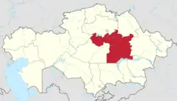 | |
| Major cities | ||