Oberbarnim
Oberbarnim | |
|---|---|
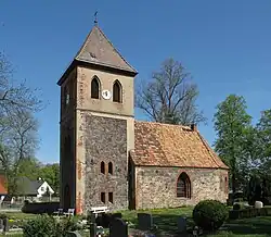 Church in Bollersdorf village | |
Location of Oberbarnim within Märkisch-Oderland district 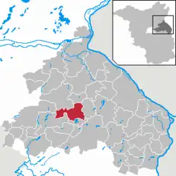 | |
 Oberbarnim  Oberbarnim | |
| Coordinates: 52°35′38″N 14°2′8″E / 52.59389°N 14.03556°E | |
| Country | Germany |
| State | Brandenburg |
| District | Märkisch-Oderland |
| Municipal assoc. | Märkische Schweiz |
| Government | |
| • Mayor (2024–29) | Detlef Daubitz[1] |
| Area | |
• Total | 52.57 km2 (20.30 sq mi) |
| Elevation | 95 m (312 ft) |
| Population (2023-12-31)[2] | |
• Total | 2,055 |
| • Density | 39/km2 (100/sq mi) |
| Time zone | UTC+01:00 (CET) |
| • Summer (DST) | UTC+02:00 (CEST) |
| Postal codes | 15377, 15345 |
| Dialling codes | 033433, 03341, 033436, 033437 |
| Vehicle registration | MOL |
Oberbarnim is a municipality in the district Märkisch-Oderland, in Brandenburg, Germany.
The municipality is situated largely in the Märkische Schweiz Nature Park and consists of the following quarters (German: Ortsteile):
- Bollersdorf
- Pritzhagen (with Tornow)
- Grunow (with Ernsthof)
- Klosterdorf
- Ihlow.
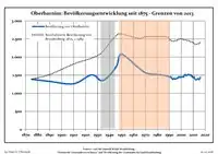
Demography
|
|
References
- ^ Landkreis Märkisch-Oderland Wahl der Bürgermeisterin / des Bürgermeisters. Retrieved 10 July 2024.
- ^ "Bevölkerungsstand im Land Brandenburg Dezember 2023] (Fortgeschriebene amtliche Einwohnerzahlen, basierend auf dem Zensus 2022)". Amt für Statistik Berlin-Brandenburglanguage=German.
- ^ Detailed data sources are to be found in the Wikimedia Commons.Population Projection Brandenburg at Wikimedia Commons
External links
![]() Media related to Oberbarnim at Wikimedia Commons
Media related to Oberbarnim at Wikimedia Commons