Ohio State Route 100
 State Route 100 | ||||
|---|---|---|---|---|
 | ||||
| Route information | ||||
| Maintained by ODOT | ||||
| Length | 39.02 mi[1] (62.80 km) | |||
| Existed | 1924–present | |||
| Major junctions | ||||
| South end | ||||
| North end | ||||
| Location | ||||
| Country | United States | |||
| State | Ohio | |||
| Counties | Marion, Crawford, Seneca | |||
| Highway system | ||||
| ||||
| ||||

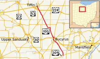
State Route 100 (SR 100) is a north–south highway in northwestern Ohio. Its southern terminus is at State Route 309 near Iberia, and its northern terminus is at State Route 53 in Tiffin.
History
- 1924 – Original route established. Originally routed from 1-mile (1.6 km) north of Brokensword to Tiffin.[2]
- 1939 - Extended to 12 miles (19 km) south of Bucyrus along route 19 from 1-mile (1.6 km) north of Brokensword to 3 miles (4.8 km) south of Bucyrus and an unnumbered road from 3 miles (4.8 km) south of Bucyrus to 12 miles (19 km) south of Bucyrus.[2]
Major intersections
| County | Location | mi | km | Destinations | Notes |
|---|---|---|---|---|---|
| Marion | Iberia | 0.0 | 0.0 | Southern Terminus. | |
| Crawford | Bucyrus | 9.11 | 14.66 | Southern terminus of SR 19 concurrency; SR 19 continues south. | |
| 12.53 | 20.17 | Southern terminus of SR 4/SR 98 concurrency; SR 4/SR 98 continue south. | |||
| 12.67 | 20.39 | Northern terminus of SR 98 concurrency; SR 98 continues north. | |||
| 13.46 | 21.66 | Full-access interchange with US 30. | |||
| 14.02 | 22.56 | Northern terminus of SR 4 concurrency; SR 4 continues north. | |||
| Lykens Township | 21.3 | 34.3 | Northern terminus of SR 19 concurrency; SR 19 continues north. | ||
| 25.12 | 40.43 | Eastern terminus of SR 103 concurrency; SR 103 continues east. | |||
| 25.26 | 40.65 | Western terminus of SR 103 concurrency; SR 103 continues west. | |||
| Seneca | Melmore | 30.57 | 49.20 | Southern terminus of SR 67 concurrency; SR 67 continues south. | |
| 30.83 | 49.62 | Northern terminus of SR 67 concurrency; SR 67 continues north. | |||
| Tiffin | 35.56 | 57.23 | |||
| 37.88 | 60.96 | Southern terminus of SR 231 concurrency; SR 231 continues south. | |||
| 38.23 | 61.53 | Northern terminus of SR 231 concurrency; SR 231 ends. | |||
| 38.29 | 61.62 | ||||
| 39.02 | 62.80 | Northern terminus. | |||
1.000 mi = 1.609 km; 1.000 km = 0.621 mi
| |||||
References
Template:Attached KML/Ohio State Route 100
KML is from Wikidata
- ^ Ohio Department of Transportation. "Technical Services Straight Line Diagrams". Retrieved April 30, 2010.
- ^ a b Route 100 (The Unofficial Ohio State Highways Web Site) by John Simpson Archived December 26, 2004, at the Wayback Machine