Ohio State Route 635
 State Route 635 | ||||
|---|---|---|---|---|
 | ||||
| Route information | ||||
| Maintained by ODOT | ||||
| Length | 15.18 mi[1] (24.43 km) | |||
| Existed | 1937[2][3]–present | |||
| Major junctions | ||||
| South end | ||||
| North end | ||||
| Location | ||||
| Country | United States | |||
| State | Ohio | |||
| Counties | Seneca, Sandusky | |||
| Highway system | ||||
| ||||
| ||||

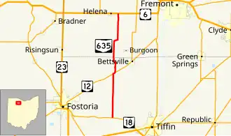
State Route 635 (SR 635) is a north–south state highway in the northwestern portion of the U.S. state of Ohio. The southern terminus of SR 635 is at SR 18 in Bascom. Its northern terminus is approximately 1 mile (1.6 km) east of Helena at a T-intersection with US 6.
Route description
SR 635 travels through northwestern Seneca County and southwestern Sandusky County along its way. The highway is not included as a part of the National Highway System, a network of highways deemed to be most important for the nation's economy, mobility and defense.[4]
History
The designation of SR 635 took place in 1937. Its original routing between SR 18 in Bascom and US 6 near Helena is the same one that it utilizes to this day. No significant changes have taken place to the alignment of SR 635 since it was established.[2][3]
Major intersections
| County | Location | mi[1] | km | Destinations | Notes |
|---|---|---|---|---|---|
| Seneca | Bascom | 0.00 | 0.00 | ||
| Liberty Township | 6.08 | 9.78 | Southern end of SR 12 concurrency | ||
| 6.33 | 10.19 | Northern end of SR 12 concurrency | |||
| Sandusky | Jackson Township | 15.18 | 24.43 | ||
1.000 mi = 1.609 km; 1.000 km = 0.621 mi
| |||||
References
- ^ a b Ohio Department of Transportation. "Technical Services Straight Line Diagrams". Retrieved July 6, 2008.
- ^ a b Official Ohio Highway Map (MrSID) (Map). Cartography by ODOH. Ohio Department of Highways. 1936. Retrieved July 6, 2008.
- ^ a b Official Ohio Highway Map (MrSID) (Map). Cartography by ODOH. Ohio Department of Highways. 1937. Retrieved July 6, 2008.
- ^ National Highway System: Ohio (PDF) (Map). Federal Highway Administration. December 2003. Archived from the original (PDF) on October 16, 2008. Retrieved January 17, 2011.